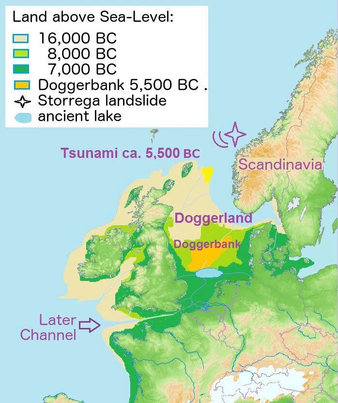
Doggerland is a submerged land mass beneath what is now the North Sea, that once connected Britain to continental Europe.
Named after the Dogger Bank, which in turn was named after the 17th-century Dutch fishing boats called doggers.
The existence of Doggerland was first suggested in a late 19th-century book “A Story of the Stone Age” by H.G. Wells, set in a prehistoric region where one might have walked dryshod from Europe to Britain.
The landscape was a diverse mix of gentle hills, marshes, wooded valleys, and swamps. Mesolithic people took advantage of Doggerland’s rich migrating wildlife and seasonal hunting grounds that have been evident in the ancient bones and tools embedded on the present seafloor brought to the surface by fishing trawlers.
Over time, the area was flooded by rising sea levels after the last glacial period around 6,500 to 6,200BC. Melting water that had been locked away caused the land to tilt in an isostatic adjustment as the huge weight of ice lessened.
Doggerland eventually became submerged leaving only Dogger Bank, a possible moraine (accumulation of glacial debris) which also succumbed to the sea around 5000BC.
A recent theory among archaeologists suggests that much of the remaining coast and low-lying islands was flooded around 6225–6170 BC by a mega-tsunami caused by the Storegga Slide. (The Storegga slide was a landslide that involved an estimated 180 mile length of coastal shelf in the Norwegian Sea which caused a large tsunami in the North Atlantic Ocean).
Archaeology discoveries within the Doggerland region have included the remains of mammoth, rhinoceros and hunting artefacts that have all been dredged up from the sea floor of the North Sea.
In 1931, a famous discovery made the headlines when a trawler named Colinda hauled up a lump of peat whilst fishing near the Ower Bank, 25 miles off the English coast. To the astonishment of the fisherman, the peat contained an ornate barbed antler point used for harpooning fish that dated from between 10,000-4,000 BC.
Other extensive discoveries of prehistoric finds have included textile fragments, paddles and Mesolithic dwellings just off the coast of Denmark. In addition, settlements with sunken floors, dugout canoes, fish traps and a number of burials in the Rhine/Meuse delta of the Netherlands, and a skull fragment of a Neanderthal, dated at over 40,000 years old dredged from the Middeldiep off the coast of Zeeland.
Divers have even discovered patches of prehistoric forests, like the discovery in 2015 off the coast of Norfolk, when the research group “Seasearch” was studying marine life and unexpectedly found remains of compressed trees and branches.

Several Universities have presently been involved in numerous studies in order to map the geology of Doggerland, understand the flora and fauna of this forgotten land.
The story of Doggerland is a cautious warning as to the power nature wields in shaping the landscape through climate change. Entire peoples found themselves displaced as the sea encroached on a region larger than many European countries. Today, over 1 billion people live close to coast lines, in vulnerable areas.
Header Image Credit : Daleyhl


