Laser from a plane discovers Roman goldmines in Spain

0

Las Médulas in León is considered to be the largest opencast goldmine of the Roman Empire, but the search for this metal extended many kilometres further south-east to the Erica river valley.

Thanks to a Light Detection and Ranging (LiDAR) laser system attached to an aircraft, the ancient mining works of the area and the complex hydraulics system used by the Romans in the 1st century BC to extract gold (including channels, reservoirs and a double river diversion) have been discovered.

These are ancient goldmines in the Eria river valley, with channels and reservoirs for exploitation. The model generated with LiDAR data (left)

“The volume of earth exploited is much greater than previously thought and the works performed are impressive, having achieved actual river captures, which makes this valley extremely important in the context of Roman mining in the north-east of the Iberian Peninsula,” as Javier Fernández Lozano, geologist at the University of Salamanca and co-author of this study published in the ‘Journal of Archaeological Science’, tells SINC.

The specialists consider that the systems for the transport and storage of water were copied from those already existing in North Africa, where the Egyptians had been employing them for centuries. Some details of the methodology used appear in texts such as those of the Pliny the Elder, the Roman procurator in charge of overseeing mining in Hispania.

“We have established that the labour that went into extracting the resource until its exhaustion was so intensive that after removing the gold from surface sediments, operations continued until reaching the rocks with the auriferous quartz veins underneath,” explains Fernández Lozano.

The researcher stresses that the real discoverer was the LiDAR technology: “Unlike traditional aerial photography, this airborne laser detection system allows the visualisation of archaeological remains under vegetation cover or intensely ploughed areas”.

From aircraft or drones

These are ancient goldmines in the Eria river valley, with channels and reservoirs for exploitation. The model generated allows these structures to be located on aerial photos (right).

LiDAR comprises a laser sensor which scans the ground from an aircraft or drone with geographical references provided by GPS ground stations. The data obtained is represented by point clouds, which are processed with a piece of software to construct a cartographic model where the forms are identified, such as old reservoirs or channels.

This technology was developed by NASA in the sixties to analyse the retreating sea ice in the Arctic and composition of the oceans. Since then their use has been extended to topography, cadastral mapping, geology and archaeology. According to the authors, the study of Roman mining in the Eria valley is the first piece of ‘geo-archaeology’ performed with LiDAR in Spain.

“Our intention is to continue working with this technique to learn more about mineral mining in the Roman Empire and clear up any mysteries such as why Rome abandoned such a precious resource as gold from one day to the next,” concludes the researcher.

FECYT – Spanish Foundation for Science and Technology


PLEASE SUPPORT OUR CROWDFUNDER ON KICKSTARTER

THE-Heritage Explorer (Magazine)

Support us in launching a printed magazine that explores the history, archaeology, travel, culture and exploration of the world.

THE Heritage Explorer is an exciting print magazine and publishing business proposal dedicated to delivering you the latest exploration, travel, archaeology, culture and heritage news.

A concept born out of the aspirations of a team of journalists, archaeologists and historians to build a credible and sustainable publishing business that will not only provide the public with entertaining articles and up-to-date research, but also to develop career opportunities for all those involved.

This is not just a magazine, but the opportunity for you to plant the seeds for a real contender in the publishing market place. Find out more

Anthropologist uncovers issues of gender inequality in archaeology journals

0

On an archaeology field trip in New Mexico as an undergraduate in 2006, Dana Bardolph noticed something that struck her as an odd gender imbalance: The professor leading the dig was a men, while the graduate assistant and all but two of the 14 undergrads were women.

“And it just got me thinking,” Bardolph recalled. “Is this reflective of the profession as a whole, or is it an anomaly?”

The question stayed with her, and four years ago she decided to search for an answer. Her findings — generated after digging through more than 4,500 peer-reviewed papers in 11 archaeology journals covering a 23-year period — are published in a recent issue of the archaeology journal American Antiquity.

Bardolph, a Ph.D. student in UC Santa Barbara’s Department of Anthropology, found that female authors are significantly and consistently underrepresented in American archaeology journals. Indeed, although the gender ratio among researchers is roughly equal, in the journals Bardolph surveyed, female authors account for slightly less than 29 percent of articles published.

“I found that there was no significant difference between any of the regions, any of the journals, so it was really a ubiquitous pattern across the study samples,” Bardolph said.

The results, she and researchers familiar with the paper said, have deep implications not just for women in the field but for the direction and substance of archaeology itself. Bardolph argues, based on feminist theory, that the low rates of publication perpetuate a marginalization of female researchers in academia and demonstrate what she called “a pernicious historical bias with regards to the visibility, recognition, presentation and circulation of women’s writing.”

Bardolph’s adviser, Amber VanDerwarker, associate professor of anthropology and director of UCSB’s Integrative Subsistence Laboratory, said the paper has the potential to catalyze a movement toward greater gender equity in publishing and academia. “It is hugely significant because there have been articles here and there that talk about this issue of gender equity in the field,” she said, “and none of the studies has done this much data collection and analysis; this is the first study of this scale looking at publication rates.”

Among the articles surveyed in the major journals, Bardolph found 71.4 percent were lead-authored by men and 28.6 percent by women. The regional journals revealed nearly identical numbers. In addition, the data were consistent over time.

While the data demonstrated a clear gender bias, what they didn’t show is the source, said Bardolph, whose specialty is paleoethnobotany, a study of the relationship between humans and plants in the past.

The journals don’t track submissions by gender, so there’s no way to tell if men are being favored explicitly, she said. Other studies, however, have found that men submit papers far more often than women do, with equal rejection rates among the genders.

Based on her research, Bardolph said she suspects the bias is likely a result of authorial behavior rather than editorial or reviewer bias. Women, she noted, are more likely to take on “nurturing” roles in academia and accept positions in smaller teaching colleges as opposed to large research universities with their more abundant resources.

“When you have grad students you can collaborate with, you publish more than you would if you were doing everything by yourself,” VanDerwarker said. “I spent a few years at a teaching college just struggling to keep up with the publication record.”

Another potential factor Bardolph noted is more subjective: braving the sometimes-brutal journal submission process. The anonymity of peer reviewers occasionally engenders harsh rejections. And archaeology, which has long been dominated by men, is no exception.

“I think it’s highly plausible that the issue of rejection ¾ and whether you do decide to revise and resubmit or discard the manuscript — has a lot to do with confidence issues,” Bardolph said. “I wouldn’t be surprised if that was in fact the case, that perhaps women were revising and resubmitting less often than men.”

For Bardolph, getting academia to acknowledge gender bias is just one step on a long road to equality. “People aren’t really realizing this sort of inequality is still pervasive,” she said. “My real goal is to bring awareness to the issue and to inspire people to delve more deeply into their particular subdisciplines and continue this type of research so we can continue to explore why these inequities perpetuate and think about what we can do about them.”

University of California – Santa Barbara


PLEASE SUPPORT OUR CROWDFUNDER ON KICKSTARTER

THE-Heritage Explorer (Magazine)

Support us in launching a printed magazine that explores the history, archaeology, travel, culture and exploration of the world.

THE Heritage Explorer is an exciting print magazine and publishing business proposal dedicated to delivering you the latest exploration, travel, archaeology, culture and heritage news.

A concept born out of the aspirations of a team of journalists, archaeologists and historians to build a credible and sustainable publishing business that will not only provide the public with entertaining articles and up-to-date research, but also to develop career opportunities for all those involved.

This is not just a magazine, but the opportunity for you to plant the seeds for a real contender in the publishing market place. Find out more

Dating of Viking fortress could suggest it belonged to Harald Bluetooth

0

In September 2014, archaeologists from the Danish Castle Centre and Aarhus University announced the discovery of a Viking fortress in a field belonging to Vallø Manor, located west of Køge on the east coast of Sealand.

This was the first discovery of its kind in Denmark in over 60 years. Since then, archaeologists have been waiting impatiently for the results of the dating of the fortress.

“When the discovery was published back in September, we were certain that we had found a Viking ring fortress, but since then there have been intense discussions online and amongst archaeologists about whether we were right. Now we know without doubt that we have found a fortress from the 10th century,” says archaeologist Nanna Holm, curator of the Danish Castle Centre.

© Nanna Holm, Danmarks Borgcenter

Two carbon-14 dating results have removed all doubt regarding the authenticity of the Viking fortress. The carbon-14 dating was performed by the AMS 14C Dating Centre at the Department of Physics and Astronomy at Aarhus University in close collaboration with Accium BioSciences’ laboratories in Seattle.

“The two samples were both taken from the outermost tree rings of charred logs that were found in the northern gateway of the fortress. The results of the two samples are almost identical: The fortress was built in the period between the year 900 and the beginning of the 11th century,” explains Marie Kanstrup, an employee at the AMS 14C Dating Centre at the Department of Physics and Astronomy, Aarhus University.

Dating is important in determining the role of the fortress in the history of the Viking age

Søren Sindbæk, a professor of medieval archaeology at Aarhus University, explains that archaeologists are still working to date the fortress more precisely.

“We would like to determine a specific year. The carbon-14 method can’t provide that, but we are working on different methods that can help us date the fortress even more precisely.”

“We can’t say whether or not it’s Harald Bluetooth’s fortress yet, but now that we’ve dated it to the 10th century, the trail is getting hotter.

The things we’ve discovered about the fortress during the excavations all point in the same direction. We already know that there’s a good chance that we’ll find conclusive evidence next year,” says Sindbæk.

A structure meant to symbolise power

Even though the excavations have closed for this year, the finds bode well for future efforts. The archaeologists’ investigations have also revealed that the Viking fortress was built right next to the open sea.

YouTube video

“The excavation showed that there was a basin of fresh or brackish water right next to one side of the fortress – presumably a quite narrow inlet leading out to Køge Bay. When the fortress was built, hundreds of tonnes of the heavy clay subsoil would have had to have been dug out into the sea basin,” explains Nanna Holm.

According to Nanna Holm, this work was undertaken for no other reason than to give the fortress an impressive location. The structure was meant to signal power.

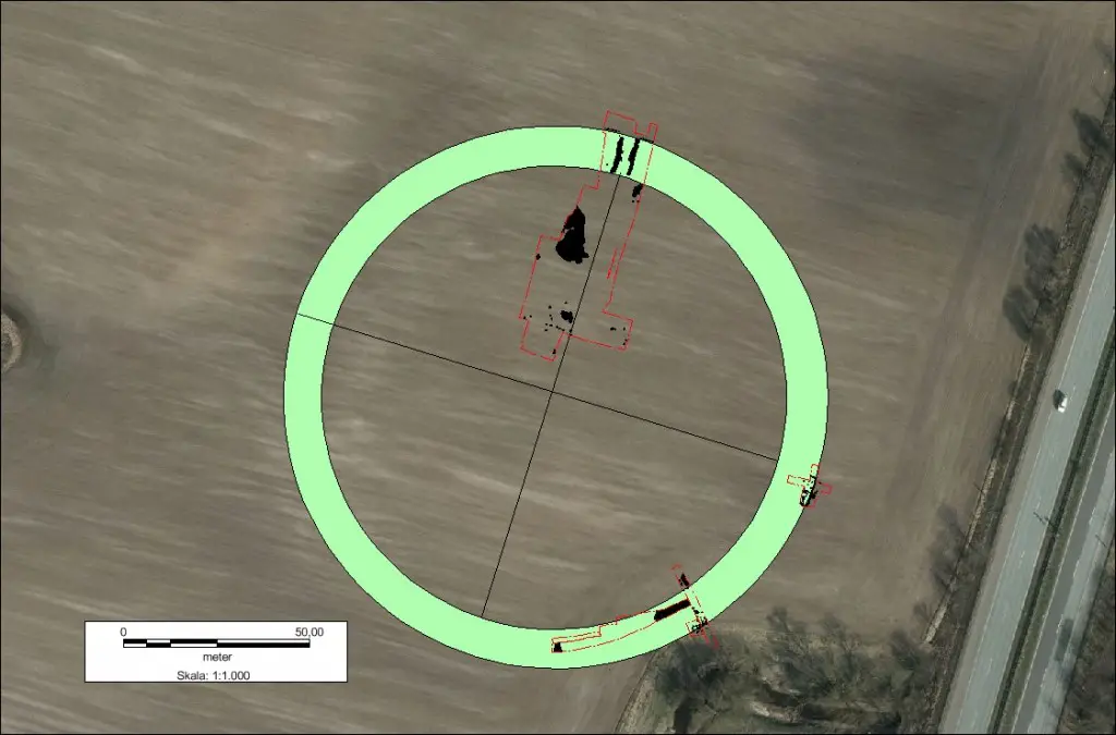
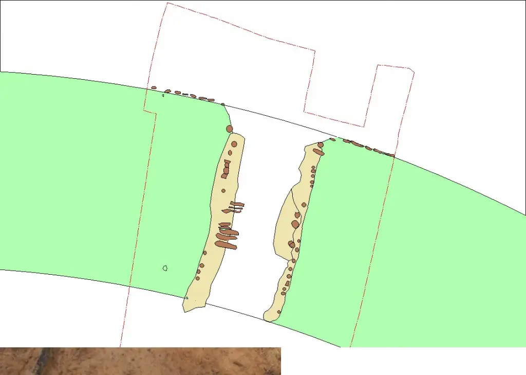
North Port : Retail Plan of the excavation around the castle's north gate . The plan shows the tracks of timber structures from the collapsed port . © Nanna Holm , Danish Castle Centre
North Port : Retail Plan of the excavation around the castle’s north gate . The plan shows the tracks of timber structures from the collapsed port . © Nanna Holm , Danish Castle Centre

The same master builder may be responsible

The excavation has also shown that the construction of the fortress is closely related to other Viking fortresses such as Fyrkat near Hobro, Aggersborg near the Limfjord and Trelleborg near Slagelse. These fortresses were undoubtedly built during the reign of Harald Bluetooth, and still more evidence suggests that Borgring, as the fortress has been named, might have belonged to the same building programme.

“There are a lot of similar details in these structures. And it’s been wonderful to see the same things coming to light at Borgring. In addition to the structure of the rampart and the gates, we have also found traces of a street with wood paving running along the inside of the rampart – just like in Fyrkat, Aggersborg and Trelleborg. The most striking thing, however, is the measurements of the fortress. The rampart of Borgring is 10.6 metres wide. That is exactly the same width as the rampart of Fyrkat. So it’s hard to avoid the sense that the same master builder was responsible,” says Sindbæk.

Aarhus University


PLEASE SUPPORT OUR CROWDFUNDER ON KICKSTARTER

THE-Heritage Explorer (Magazine)

Support us in launching a printed magazine that explores the history, archaeology, travel, culture and exploration of the world.

THE Heritage Explorer is an exciting print magazine and publishing business proposal dedicated to delivering you the latest exploration, travel, archaeology, culture and heritage news.

A concept born out of the aspirations of a team of journalists, archaeologists and historians to build a credible and sustainable publishing business that will not only provide the public with entertaining articles and up-to-date research, but also to develop career opportunities for all those involved.

This is not just a magazine, but the opportunity for you to plant the seeds for a real contender in the publishing market place. Find out more

Climate change was not to blame for the collapse of the Bronze Age

Scientists will have to find alternative explanations for a huge population collapse in Europe at the end of the Bronze Age as researchers prove definitively that climate change – commonly assumed to be responsible – could not have been the culprit.

Archaeologists and environmental scientists from the University of Bradford, University of Leeds, University College Cork, Ireland (UCC), and Queen’s University Belfast have shown that the changes in climate that scientists believed to coincide with the fall in population in fact occurred at least two generations later.

Their results, published this week in Proceedings of the National Academy of Sciences, show that human activity starts to decline after 900BC, and falls rapidly after 800BC, indicating a population collapse. But the climate records show that colder, wetter conditions didn’t occur until around two generations later.

Fluctuations in levels of human activity through time are reflected by the numbers of radiocarbon dates for a given period. The team used new statistical techniques to analyse more than 2000 radiocarbon dates, taken from hundreds of archaeological sites in Ireland, to pinpoint the precise dates that Europe’s Bronze Age population collapse occurred.

The team then analysed past climate records from peat bogs in Ireland and compared the archaeological data to these climate records to see if the dates tallied. That information was then compared with evidence of climate change across NW Europe between 1200 and 500 BC.

“Our evidence shows definitively that the population decline in this period cannot have been caused by climate change,” says Ian Armit, Professor of Archaeology at the University of Bradford, and lead author of the study.

Graeme Swindles, Associate Professor of Earth System Dynamics at the University of Leeds, added, “We found clear evidence for a rapid change in climate to much wetter conditions, which we were able to precisely pinpoint to 750BC using statistical methods.”

According to Professor Armit, social and economic stress is more likely to be the cause of the sudden and widespread fall in numbers. Communities producing bronze needed to trade over very large distances to obtain copper and tin. Control of these networks enabled the growth of complex, hierarchical societies dominated by a warrior elite. As iron production took over, these networks collapsed, leading to widespread conflict and social collapse. It may be these unstable social conditions, rather than climate change, that led to the population collapse at the end of the Bronze Age.

According to Katharina Becker, Lecturer in the Department of Archaeology at UCC, the Late Bronze Age is usually seen as a time of plenty, in contrast to an impoverished Early Iron Age. “Our results show that the rich Bronze Age artefact record does not provide the full picture and that crisis began earlier than previously thought,” she says.

“Although climate change was not directly responsible for the collapse it is likely that the poor climatic conditions would have affected farming,” adds Professor Armit. “This would have been particularly difficult for vulnerable communities, preventing population recovery for several centuries.”

The findings have significance for modern day climate change debates which, argues Professor Armit, are often too quick to link historical climate events with changes in population.

“The impact of climate change on humans is a huge concern today as we monitor rising temperatures globally,” says Professor Armit.

“Often, in examining the past, we are inclined to link evidence of climate change with evidence of population change. Actually, if you have high quality data and apply modern analytical techniques, you get a much clearer picture and start to see the real complexity of human/environment relationships in the past.”

University of Bradford


PLEASE SUPPORT OUR CROWDFUNDER ON KICKSTART

THE-Heritage Explorer (Magazine)

Support us in launching a printed magazine that explores the history, archaeology, travel, culture and exploration of the world.

THE Heritage Explorer is an exciting print magazine and publishing business proposal dedicated to delivering you the latest exploration, travel, archaeology, culture and heritage news.

A concept born out of the aspirations of a team of journalists, archaeologists and historians to build a credible and sustainable publishing business that will not only provide the public with entertaining articles and up-to-date research, but also to develop career opportunities for all those involved.

This is not just a magazine, but the opportunity for you to plant the seeds for a real contender in the publishing market place. Find out more

Ancient DNA sheds light on the origin of Europeans

Much of the evidence of where the first Europeans came from was originally derived from comparisons of skulls but our work looking at ancient DNA is revealing new insight, with results published this month in Science.

Before we go any further, we need to look at what the skulls were telling us. Over a number of decades from the 1970s the US physical anthropologist William Howells recorded tens of thousands of human skulls held in museum collections across the world.

The patterns identified by Howells established that there were distinct correlations between geography and human biology, which provided insights into our understanding of the population history of the world.

In 1989 Howells included a number of fossil human skulls in this comparison to see if they could shed insights into the understanding of modern human dispersals.

Are the first Australians and Europeans related?

One of the patterns to emerge was that many of the earliest European modern human skulls from the last Ice Age, commonly referred to as the Cro-Magnon people, sat statistically very close to Aboriginal Australians and Papua New Guineans.

Did this reflect a close common origin between the first Europeans and the first Australians? Our research, led by Eske Willerslev from the University of Copenhagen, reveals the answer to this is “not really”.

The genome recovered from an ancient skeleton, from a site known as Kostenki 14, has revealed an important story about the human history of Europe.

The remains there, found in 1954 at Kostenki, in south western Russia, were from a short, dark-skinned man who lived between 38,700 to 36,200 years ago.

It is generally accepted today that multivariate analyses comparing ancient and modern skulls do not necessarily indicate a stronger biological relationship between similarly looking skulls.

Instead it reflects such things as the kinds of patterns that we see in many early modern human fossils that are comparatively large and robust, when compared to later Holocene populations.

The story from ancient DNA is, however, far more complex.

Among the remains from the very ancient Russian, from Kostenki 14, is one of the earliest and most complete modern human skulls from Europe.

In Howells’ original multivariate analysis the skull sat statistically very closely to the first Australians, but his DNA tells a very different story.

Our study shows that Kostenki 14 shared genetic ancestry with hunter-gatherers in Europe, as well as with the early farmers, suggesting that his ancestors interbred with members of the same Middle Eastern population who later turned into farmers and came to Europe themselves.

This lead Eske Willerslev to remark: “Kostenki was already pure European.”

Out of Africa

All modern humans (Russians and Australians included) are derived from an initial migration out of Africa. From the fossil record this seems to have occurred sometime around 100,000 years ago in the Near East, at Skhul and Qafzeh.

This initial Homo sapiens range expansion from Africa was initially thought to have been short-lived, with Homo neanderthalensis returning to South West Asia some 60,000 years ago.

Apart from what his genome tells us about European origins, the Kostenki 14 genome is also fascinating because it contains the genetic record of a period shortly after the ancestors of Europeans hybridised with Neanderthals.

We now know that humans and Neanderthals mixed early in human history, sometime before 45,000 years ago. This is shown by the fact that the genome of Kostenki 14 had slightly more Neanderthal DNA than do Europeans and Asians today, perhaps as much as 1% more.

And his DNA comprises long tracts of Neanderthal DNA, much longer than that found in many non-African people now. In fact the longest of these totals about 3 million base pairs.

After the period of ancient hybridisation, these long DNA sequences start to be broken up by the processes of sexual reproduction. But Kostenki 14 has these well preserved long sequences.

The research team then used the length of these tracts of Neanderthal DNA to better estimate the admixture time of Neanderthals and humans and obtained a date of approximately 54,000 years.

We note that genomic data from a 45,000-year-old modern human from Siberia, which were published during the review process of our study, also shows longer segments of Neanderthal ancestry, further supporting our conclusions.

Because of the divergent position of the Kostenki 14 sample, the team also asked if it contained any fragments of admixed DNA from other previously un-sampled hominins. Interestingly, the distribution of tracts of divergent DNA provides no evidence for other DNA sequences showing evidence of gene flow from other archaic humans.

The sequencing of the genome of Kostenki 14 is a major technical and scientific achievement and illustrates the importance of recovering genomes from ancient remains for understanding the complexity of human origins.

Only when we have entire genomes captured from back in time, as was possible with Kostenki 14, can we better detect and measure important events in the past history of species such as our own.

The Conversation


PLEASE SUPPORT OUR CROWDFUNDER ON KICKSTART

THE-Heritage Explorer (Magazine)

Support us in launching a printed magazine that explores the history, archaeology, travel, culture and exploration of the world.

THE Heritage Explorer is an exciting print magazine and publishing business proposal dedicated to delivering you the latest exploration, travel, archaeology, culture and heritage news.

A concept born out of the aspirations of a team of journalists, archaeologists and historians to build a credible and sustainable publishing business that will not only provide the public with entertaining articles and up-to-date research, but also to develop career opportunities for all those involved.

This is not just a magazine, but the opportunity for you to plant the seeds for a real contender in the publishing market place. Find out more

Climate capers of the past 600,000 years

0

If you want to see into the future, you have to understand the past. An international consortium of researchers under the auspices of the University of Bonn has drilled deposits on the bed of Lake Van (Eastern Turkey) which provide unique insights into the last 600,000 years.

The samples reveal that the climate has done its fair share of mischief-making in the past. Furthermore, there have been numerous earthquakes and volcanic eruptions. The results of the drilling project also provide a basis for assessing the risk of how dangerous natural hazards are for today’s population. In a special edition of the highly regarded publication Quaternary Science Reviews, the scientists have now published their findings in a number of journal articles.

In the sediments of Lake Van, the lighter-colored, lime-containing summer layers are clearly distinguishable from the darker, clay-rich winter layers — also called varves. In 2010, from a floating platform an international consortium of researchers drilled a 220 m deep sediment profile from the lake floor at a water depth of 360 m and analyzed the varves. The samples they recovered are a unique scientific treasure because the climate conditions, earthquakes and volcanic eruptions of the past 600,000 years can be read in outstanding quality from the cores.

The team of scientists under the auspices of the University of Bonn has analyzed some 5,000 samples in total. “The results show that the climate over the past hundred thousand years has been a roller coaster. Within just a few decades, the climate could tip from an ice age into a warm period,” says Doctor Thomas Litt of the University of Bonn’s Steinmann Institute and spokesman for the PALEOVAN international consortium of researchers. Unbroken continental climate archives from the ice age which encompass several hundred thousand years are extremely rare on a global scale. “There has never before in all of the Middle East and Central Asia been a continental drilling operation going so far back into the past,” says Doctor Litt. In the northern hemisphere, climate data from ice-cores drilled in Greenland encompass the last 120,000 years. The Lake Van project closes a gap in the scientific climate record.

The sediments reveal six cycles of cold and warm periods

Scientists found evidence for a total of six cycles of warm and cold periods in the sediments of Lake Van. The University of Bonn paleoecologist and his colleagues analyzed the pollen preserved in the sediments. Under a microscope they were able to determine which plants around the eastern Anatolian Lake the pollen came from. “Pollen is amazingly durable and is preserved over very long periods when protected in the sediments,” Doctor Litt explained. Insight into the age of the individual layers was gleaned through radiometric age measurements that use the decay of radioactive elements as a geologic clock. Based on the type of pollen and the age, the scientists were able to determine when oak forests typical of warm periods grew around Lake Van and when ice-age steppe made up of grasses, mugwort and goosefoot surrounded the lake.

Once they determine the composition of the vegetation present and the requirements of the plants, the scientists can reconstruct with a high degree of accuracy the temperature and amount of rainfall during different epochs. These analyses enable the team of researchers to read the varves of Lake Van like thousands of pages of an archive. With these data, the team was able to demonstrate that fluctuations in climate were due in large part to periodic changes in the Earth’s orbit parameters and the commensurate changes in solar insolation levels. However, the influence of North Atlantic currents was also evident. “The analysis of the Lake Van sediments has presented us with an image of how an ecosystem reacts to abrupt changes in climate. This fundamental data will help us to develop potential scenarios of future climate effects,” says Doctor Litt.

Risks of earthquakes and volcanic eruptions in the region of Van

Such risk assessments can also be made for other natural forces. “Deposits of volcanic ash with thicknesses of up to 10 m in the Lake Van sediments show us that approximately 270,000 years ago there was a massive eruption,” the University of Bonn paleoecologist said. The team struck some 300 different volcanic events in its drillings. Statistically, that corresponds to one explosive volcanic eruption in the region every 2000 years. Deformations in the sediment layers show that the area is subject to frequent, strong earthquakes. “The area around Lake Van is very densely populated. The data from the core samples show that volcanic activity and earthquakes present a relatively high risk for the region,” Doctor Litt says. According to media reports, in 2011 a 7.2 magnitude earthquake in the Van province claimed the lives of more than 500 people and injured more than 2,500.

University of Bonn

Life Originated in the Earth’s Crust

0

This at least is what the geologist Prof. Dr. Ulrich Schreiber and the physico-chemist Prof. Dr. Christian Mayer of the University of Duisburg-Essen in Germany are convinced of.

It is the first model on the origin of life which includes a complete process leading from inorganic chemistry to a protocell where the problems of molecule formation, local concentration, driving force and membrane formation are being solved simultaneously” Prof. Mayer from the faculty of Chemistry says.

What is this all about? The detailed environments on the early Earth and the conditions, under which life could originate billions of years ago are largely unknown. In consequence, the possible processes which may have taken place can neither be proven nor excluded. Therefore, most of the models proposed so far are focused on singular elementary steps of prebiotic developments. In its long history, the corresponding discussion about the crucial location on early Earth shifted from the Earth’s surface to the deep sea, from volcanic outlets to shallow ponds. Lacking plausible alternatives, extraterrestrial regions like Mars or the interplanetary space have also been included.

Credit : Universität Duisburg-Essen

On the other hand, the continental crust was, during a long time, neglected in the discussion. “This region, however, offers the ideal conditions for the origin of life“, Prof. Schreiber says.  His focus is on deep-reaching tectonic fault zones which are in contact with the Earth’s mantle. As for example in the region of the “Eifel” in Germany, they are channeling water, carbon dioxide and other gases which constantly rise to the surface. This fluid mixture contains all necessary ingredients for prebiotic organic chemistry.

One of the most intriguing aspects is the presence of supercritical carbon dioxide in depths below 800 meters. This supercritical fluid combines the properties of a liquid with those of a gas and presents an ideal solvent for organic chemical reactions. “This allows for many synthetic steps leading to complex biological molecules which otherwise, in a solvent like water, could not be accounted for”, Prof. Mayer explains, “Supercritical carbon dioxide acts like an organic solvent enabling reactions which would not occur in an aqueous environment. Moreover, it forms interfaces with water and hereby generates double-layer membranes which represent the most important single structural element of living cells”.

The fundamental steps of the proposed mechanisms have already been successfully reproduced in the laboratory. This includes the formation of vesicles as simple cell-like structures or the combination of amino acids to longer polymer chains forming the basis for proteins and enzymes. A fascinating detail is the fact that these processes may be proven today as they have left traces in minerals which have grown in the fault zones of the early Earth.

Prof. Oliver Schmitz, responsible for the field of trace analysis in the department of Chemistry in Essen, is convinced:  „Tiny fluid inclusions in crystals from Australian quartz dykes which have been collected by Prof. Schreiber contain a large collection of organic substances. They have been encapsulated from the fluid contents of the fault zone during the growth of the crystals. Today, they may help us to identify the chemistry which has taken place.“  With his profound experience in the analysis of natural compounds, Prof. Schmitz is a valuable asset in the research group at the University of Duisburg-Essen which deals with the fascinating question around the origin of life.

Universität Duisburg-Essen

High-Tech Authentication of Ancient Artifacts

Geologist Timothy Rose of the Smithsonian Institution’s Analytical Laboratories is accustomed to putting his lab’s high-tech nanoscale scanning electron microscope (nanoSEM) to work evaluating the mineral composition of rocks and meteorites.

Lately, though, the nanoSEM has been enlisted for a different kind of task: determining the authenticity of ancient Mesoamerican artifacts.

A 17 cm carved stone figurine shown inside the SEM chamber ready for non-destructive imaging and analysis. CREDIT: T. Rose/Smithsonian

In ongoing studies, Rose and his colleague Jane Walsh have now analyzed hundreds of artifacts, including carved stone figurines and masks and ceramic pieces from the ancient Olmec, Maya, Teotihuacan and Mezcala civilizations dating from 1500 B.C. to A.D. 600. “With our modern imaging and analytical tools we can look at objects at very high magnification, which can reveal new details about how, and sometimes when, objects were created,” he said.

Rose will discuss the technology at the AVS 61th International Symposium and Exhibition, to be held Nov. 9-14, at the Baltimore Convention Center in Baltimore, Md.

The nanoSEM used by Rose and his colleagues has the ability to function over a range of pressures. “Being able to work in the low-vacuum mode allows us to put samples into the microscope au naturel without coating them with an electrically conductive material such as carbon, which would be almost impossible to remove from a specimen,” he said.

In one study, Rose and colleagues used the nanoSEM to study stone masks from Teotihuacan, a pre-Columbian site located 30 miles northwest of Mexico City. The masks, about the size of a human face, were too big to be put into the device (and, more importantly, could not be removed from their respective museums or drilled or otherwise altered to obtain samples for analysis). However, silicone molds that were made of the objects to study tool marks with an optical microscope did remove tiny mineral grains from deep within cracks and drill holes. Chemical evaluation of these grains using the nanoSEM’s X-ray spectrographic analysis system showed that some were diatoms—common single-celled algae with cell walls made of silica. Diatomaceous earth is “a very fine powdery siliceous rock comprised entirely of diatoms that would make very nice polish for the stone of these specific masks,” Rose said. “We believe we found abrasive grains and polish that was used in the manufacturing process.”

In a separate study of artifacts confiscated by the federal government, the researchers found some pieces to be partially coated with a layer of what looked to be modern gypsum plaster. In other words, the pieces were fakes. However, Rose noted, a surprisingly small percentage of the objects evaluated to date have shown modern tools marks or other evidence of recent origins. One unique ceramic handled pot analyzed in detail, for example, had five chemically distinct layers that appeared to be original Olmec fresco paint—a level of craftsmanship that, he said, is unlikely to have been the work of modern artisans.

Tell-tales of war: Traditional stories highlight how ancient women survived

0

Through the ages, women have suffered greatly because of wars. Consequently, to protect themselves and their offspring, our female ancestors may have evolved survival strategies specific to problems posed by warfare, says Michelle Scalise Sugiyama of the University of Oregon in the US.

Her findings, based on the comprehensive analysis of traditional stories from across the world, are published today in Springer’s journal Human Nature. The work is of interest because research to date has focused on the problems warfare poses for men, and how these problems shaped human male cognition.

Scalise Sugiyama studied a sample of forager and forager-horticulturalist societies by looking at archaeological and ethnographic research on lethal raiding. This helped her to compile a list of five ‘fitness costs’ – ways in which warfare impedes women’s chances of surviving and reproducing. These occur when a woman is killed, a woman is captured, her offspring is killed, a mate is killed or captured, or an adult male kinsman is killed or captured.

The study then reviewed traditional stories about lethal raids that had been handed down for generations by word of mouth. Scalise Sugiyama analyzed a cross-cultural sample of war stories from 45 societies and found that the five fitness costs often feature within these story lines. The war stories included tales from various North American Indian tribes, the Eskimo of the Arctic, Aborigine groups of Australia, the San of Southern Africa and certain South American tribal societies.

Based on the fitness costs documented in these stories, Scalise Sugiyama believes that ancestral women may have developed certain strategies to increase their odds of survival and their ability to manage their reproduction in the face of warfare. These include manipulating male behavior, determining whether the enemy’s intent was to kill or capture them, and using defensive and evasive tactics to sidestep being murdered or to escape captivity. Assessing the risk of resistance versus compliance also requires having several sets of knowledge. This includes information about an enemy’s warfare practices and how they treat their captives.

The so-called Stockholm Syndrome, in which hostages bond with their captors, could have ancestral roots, hypothesizes Scalise Sugiyama. It often occurs under conditions of physical confinement or physical, sexual, and/or emotional abuse, which are characteristic of captivity in ancestral forager and forager-horticulturalist groups. This response could have developed as a way to help captives identify and ultimately integrate with enemy groups. This then motivates acceptance of the situation and reduces attempts to resist the captor – which may ultimately increase a woman’s chances of survival.

“Lethal raiding has recurrently imposed fitness costs on women. Female cognitive design bears reexamination in terms of the motivational and decision-making mechanisms that may have evolved in response to them,” says Scalise Sugiyama.

Springer Science+Business Media – Header Image Credit : Rod Waddington

New Research Focuses TIGHAR’s Underwater Search for Earhart Plane

Increasing confidence that a piece of aluminum aircraft debris found on a remote, uninhabited South Pacific atoll came from Amelia Earhart’s Lockheed Electra has bolstered speculation that a sonar anomaly detected at a depth of 600 feet off the west end of the island is the lost aircraft.

In June 2015, TIGHAR will return to Nikumaroro to investigate the anomaly with Remote Operated Vehicle (ROV) technology supported by Nai’a, the 120-foot Fiji-based vessel that has served five previous TIGHAR explorations. During the twenty-four day expedition, divers will search for other wreckage at shallower depths and an onshore search team will seek to identify objects detected in historical photographs that may be relics of an initial survival camp.

YouTube video

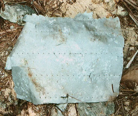
During Amelia Earhart’s stay in Miami at the beginning of her second world flight attempt, a custom-made, special window on her Lockheed Electra aircraft was removed and replaced with an aluminum patch. The patch was an expedient field modification. Its dimensions, proportions, and pattern of rivets were dictated by the hole to be covered and the structure of the aircraft. The patch was as unique to her particular aircraft as a fingerprint is to an individual. Research has now shown that a section of aircraft aluminum TIGHAR found on Nikumaroro in 1991 matches that fingerprint in many respects. For a detailed study of this important new development see The Window, The Patch, and The Artifact, Research Bulletin #73 on the TIGHAR website.

The strong possibility that Artifact 2-2-V-1 is the “Miami Patch” means that the many fractures, tears, dents and gouges evident on the metal may be important clues to the fate – and resting place – of the aircraft itself. Deciphering those clues will be the next phase in TIGHAR’s analysis of this complex and fascinating artifact.

Artifact 2-2-V-1 - Credit : Tighar
Artifact 2-2-V-1 – Credit : Tighar

Abundant evidence suggests that Earhart landed her aircraft safely on the reef at Nikumaroro and sent radio distress calls for at least five nights before the Electra was washed into the ocean by rising tides and surf leaving Earhart and Noonan cast away on the uninhabited atoll. TIGHAR researchers previously speculated that Artifact 2-2-V-1, which was found on shore, apparently washed up by a storm, might be debris from the break-up of the Electra in the surf. According to this hypothesis, the plane was torn apart and there should be other pieces scattered all along the underwater reef slope.

TIGHAR tested that hypothesis during expeditions in 2010 and 2012 but no wreckage was found. Numerous explorations of the reef slope using camera-equipped Remote Operated Vehicle (ROV) revealed no shards of aircraft wreckage and all of the sonar “targets” identified by contractor Phoenix International turned out to be coral boulders or shipwreck debris. Something was clearly wrong.

Several months after the 2012 expedition a member of TIGHAR’s online Amelia Earhart Search Forum spotted an unusual feature in the sonar imagery. During the expedition the contractor’s sonar technicians, if they noticed it all, did not alert the TIGHAR team to the anomaly in the underwater topography, so TIGHAR had no opportunity to check it out with the ROV. The object rests at a depth of six hundred feet at the base of a cliff just offshore where TIGHAR believes the Earhart aircraft was washed into the ocean. Seeking to learn more, TIGHAR commissioned an analysis of the anomaly by Ocean Imaging Consultants, Inc. of Honolulu – experts in post-processing sonar data. Their report revealed the anomaly to be the right size and shape to be the fuselage of Earhart’s aircraft. A variety of experts have, not surprisingly, offered a variety of opinions. Some are convinced the anomaly is a man-made object. Other think it is probably a geological feature. All agree that it needs to be visited.

The new research on Artifact 2-2-V-1 may reinforce the possibility that the anomaly is the rest of the aircraft. The artifact is not, as previously suspected, a random fragment from an aircraft shredded by the surf, and its removal from the aircraft appears to have been due, at least in part, to human action. That could only happen if the patch was broken out when the aircraft was on the reef surface – but when and by whom? Somehow the patch/artifact ended up on the island, so it must have either washed or been carried ashore.

If Artifact 2-2-V-1 is from the Earhart aircraft, as it appears to be, it seems to have had a different history from the rest of the aircraft. Did the underwater search for scattered wreckage fail because the wreckage is not scattered? Is the wreck of Earhart’s aircraft far more intact than TIGHAR had assumed? Is the anomaly the aircraft? The only way to now is to go look.

Tighar

What does it mean to be English?

4

An epic new history of England offers some eye-catching conclusions on Englishness – suggesting, among other things, that a “remarkable” level of cultural unity and a relative openness to other cultures are both key components of English national identity.

It may seem difficult to believe amid continual current debates over immigration, but an aversion to patriotic flag-waving and a relative tolerance of other cultures are both key components of English identity, according to a new history of England, published today.

The conclusions are just two of those reached in The English and Their History, a sweeping survey of the last 13 centuries by the historian Professor Robert Tombs which, by examining the development of the nation and Englishness since Anglo-Saxon times, attempts to answer the enduring and complex question of what it means to be English.

Part of that answer, he suggests, is to be found in a healthy “nonchalance” about national identity that has made the English – while by no means saints – resistant to racism and broadly tolerant of other cultures.

This is, however, only one small piece of the extensive verdict that Tombs, who teaches and researches modern European History at St John’s College, University of Cambridge, reaches in the conclusion of a study that has been six years in the making.

Elsewhere, he perhaps surprisingly argues that the widespread view that England is in a state of post-Imperial political and economic decline is a myth. The book also suggests that political isolationism from larger structures – whether the Empire or Europe – has rarely been a part of English history or nature, and identifies a fascinating history of political polarisation on sectarian lines that has, in the modern age, evolved into the split between “Ambridge and Coronation Street”.

The book, published on Thursday, November 6 by Allen Lane, is the first single-volume history of England to be produced on this scale since the 1930s. Starting in the Anglo-Saxon era and ending in 2014, it aims in part to explore, through the English people’s developing understanding of themselves, what their history means at a time when ties within the United Kingdom appear to be loosening.

“It tries to reflect on how we have understood history, what the past means to us today, and what it might mean to us in the future,” Tombs said. “It is an attempt to say, ‘this is the sort of country we are, and this is what our history has made us’. It’s up to the reader to decide how to use that and whether or not they agree.”

While the multicultural character of English history has been well-documented, Tombs argues that a tolerance of other peoples and, historically, of immigration, has become a component of the country’s national identity.

Central to his argument is the fact that England has, for very little of its history, stood alone. Most of the time it has been the core nation in a multinational state, or at one stage in the Empire. Only between King Alfred and King Cnut, and then during the Tudor period (along with Wales), did England operate as an isolated political entity.

Because of this, the book suggests that English identity tends not to be expressed in terms of ethnic purity or cultural distinctiveness, and it has typically made little political sense for England to “beat the nationalist drum”. Instead, Tombs argues that England has historically propagated its values through interaction with others – spreading Christianity in Medieval times, as a force for European civilisation and free trade more recently, and as an Empire. The result, he says, is that Englishness is not founded on ideas of opposition and exclusion, but on inclusion and expansion.

One effect of this is a general “nonchalance” about national identity. “We don’t normally go in for a lot of flag-waving, we find that fairly un-English,” Tombs said. “That nonchalance has made us pretty resistant to racism. That is not to deny that racism has played a part in English history, but it has not been a defining character of our history. And thanks to our memory of resistance to Hitler in the Second World War there is no nostalgia for Fascism in England as we are now seeing in several other countries.”

While some agonise over the lack of a clear patriotic identity or devotion to the national flag, Tombs argues that “there is something to be said for national nonchalance”.

“In recent decades, the English have largely accommodated the shifts brought by changing moralities and multi-ethnicity, incorporating them into new varieties of Englishness,” he writes. “Who could be more English today than Rita Ora and Dizzee Rascal, Jessica Ennis and Rio Ferdinand?”

Another eye-catching argument within Tombs’ extensive survey is that “declinism” – the suggestion that England and Britain as a whole have lost economic and political standing on the world stage since the end of Empire – is a myth.

Key to this is one of the book’s central propositions – that the history of England shows the nation to have been relatively rich, secure and orderly for most of its history. Notwithstanding periods of upheaval, such as the Wars of the Roses, Peasants’ Revolt or even the Civil War (a small-scale affair compared with the prolonged and bloody experiences going on in France and Germany at the same time, Tombs says), Britain has been relatively immune to transformative catastrophes such as invasion, war and revolution.

The result is the survival of ancient buildings, cultural treasures, and national institutions such as the Crown, Parliament, shires, boroughs, the Church, universities, schools, charitable foundations, voluntary associations and more. This is reinforced by long-term cultural consistencies, in particular the use of English itself as a mainstream spoken and written language dating back to Anglo-Saxon times. “The nation changes, but it has certain structures that continue,” Tombs argues. “England has an ancient structural unity in a way that in Italy, Germany or France do not.”

Taking the same long view reveals that Britain’s power, wealth and global status has been remarkably stable, even though all are typically seen to have failed following the end of the Empire, and decolonisation. When Britain emerged as a significant force in the early 18th century, it was the smallest, and yet the most global, of the world’s half dozen most powerful states. Three centuries later it remains so, outdistanced – like all other states – only by the USA.

Other measures also raise questions about the “declinist” view that British international power has fallen, and its political and social organisation have failed. Britain in the mid-20th century was, for instance, stronger militarily than in the mid-19th, the study observes. In the 1960s it was richer than ever; by 2008 England was second only to the USA among large countries in gross per capita income.

The book is also critical of the highly centralised nature of Britain’s administration which, it points out, is a relatively recently development – “a seventy year habit that we cannot, or will not, break,” Tombs says. He argues that it leaves British governments having to handle “a neverending conveyor belt of everyday problems”, relating to transport, education, and health, for example, which other countries deliver through local government.

In a complex way this clashes with a long-standing division in the nation’s politics that, unusually, was brought about by the legal recognition given to two religious cultures in England following the “Glorious Revolution” of 1688. Unlike other countries, where a single religious denomination tends to have been dominant, England has since the 17th century held Anglicanism on the one hand, and Nonconformism on the other, in tension.

The study suggests that this unusual situation, of rival religious parties, then evolved new layers. Whig, Liberal and Labour politics were built on foundations of religious Dissent, then took on social and geographical characteristics as the country became divided between the working-class north and wealthier south.

One result of this religious point of origin, Tombs says, is that English politics has a distinctly moral and ideological tone. As a result, the commonplace details handled by a heavily-centralised Government have become the subjects of heated ideological debate – health and education are now disputed in the same terms as slavery or suffrage were in centuries past, when in most other countries they arouse far less emotion.

The over-arching message of the book is, however, a positive one, suggesting that structural and cultural unity are at the heart of what it means to be English. “We should be fairly optimistic about the future of England, as part of the UK and as a country that will want to reassess itself and will probably gain more autonomy in the coming years,” Tombs added. “The history of England shows that we have, in the long term, been very stable. We are not a nation in decline – and we never really have been.”

University of Cambridge

Tools and primates: Opportunity, not necessity, is the mother of invention

0

Whether you are a human being or an orang-utan, tools can be a big help in getting what you need to survive.

However, a review of current research into the use of tools by non-human primates suggests that ecological opportunity, rather than necessity, is the main driver behind primates such as chimpanzees picking up a stone to crack open nuts.

An opinion piece by Dr Kathelijne Koops of the University of Cambridge and others, published today (12 November 2014) in Biology Letters, challenges the assumption that necessity is the mother of invention. She and her colleagues argue that research into tool use by primates should look at the opportunities for tool use provided by the local environment.

Koops and colleagues reviewed studies on tool use among the three habitual tool-using primates – chimpanzees, orangutans and bearded capuchins.

Chimpanzees use a variety of tools in a range of contexts, including stones to crack open nuts, and sticks to harvest aggressive army ants. Orang-utans also use stick tools to prey on insects, as well as to extract seeds from fruits. Bearded capuchin monkeys living in savannah like environments also use a variety of tools, including stones to crack open nuts and sticks to dig for tubers.

The researchers’ review of the published literature, including their own studies, revealed that, against expectations, tool use did not increase in times when food was scarce. Instead, tool use appears to be determined by ecological opportunity – with calorie-rich but hard-to-reach foodstuffs appearing to act as an incentive for an ingenious use of materials.

“By ecological opportunity, we mean the likelihood of encountering tool materials and resources whose exploitation requires the use of tools. We showed that these ecological opportunities influence the occurrence of tool use. The resources extracted using tools, such as nuts and honey, are among the richest in primate habitats. Hence, extraction pays off, and not just during times of food scarcity,” said Koops.

Tool use – and transmission of tool-making and tool-using skills between individuals – is seen as an important marker in the development of culture. “Given our close genetic links to our primate cousins, their tool use may provide valuable insights into how humans developed their extraordinary material culture and technology,” said Koops.

It has been argued that culture is present among wild primates because simple ecological and genetic differences alone cannot account for the variation of behaviour – such as tool use – observed across populations of the same species.

Koops and co-researchers argue that this ‘method of exclusion’ may present a misleading picture when applied to the material aspects of culture.

“The local environment may exert a powerful influence on culture and may, in fact, be critical for understanding the occurrence and distribution of material culture. In forests with plenty of nut trees, we are more likely to find chimpanzees cracking nuts, which is the textbook example of chimpanzee material culture,” said Koops.

“Our study suggests that published research on primate cultures, which depend on the ‘method of exclusion’, may well underestimate the cultural repertoires of primates in the wild, perhaps by a wide margin. We propose a model in which the environment is explicitly recognised as a possible influence on material culture.”

Did men evolve navigation skills to find mates?

1

A University of Utah study of two African tribes found evidence that men evolved better navigation ability than women because men with better spatial skills – the ability to mentally manipulate objects – can roam farther and have children with more mates.

By testing and interviewing dozens of members of the Twe and Tjimba tribes in northwest Namibia, the anthropologists showed that men who did better on a spatial task not only traveled farther than other men but also had children with more women, according to the study published this week in the journal Evolution and Human Behavior.

“It’s the first time anybody has tried to draw a line between spatial ability, navigation, range size and reproductive success. Most of this chain has been assumed in the scientific literature,” says Layne Vashro, the study’s first author and a postdoctoral researcher in anthropology.

Anthropology professor Elizabeth Cashdan, the study’s senior author, says, “Some of the links have been demonstrated, but this study looks at the whole chain and that’s what is novel about it.”

“Among the most consistent sex differences found in the psychological literature are spatial ability and navigation ability, with men better at both,” Vashro says. “In the anthropological literature, one of the most consistent behavioral differences between men and women is the distance they travel. This difference in traveling is assumed to explain the observed differences in spatial ability and navigation ability. Now, we’ve drawn a link between spatial ability and range size.”

There is a demonstrated relationship between sex differences in how far some mammals – including voles and deer mice – range or travel, and sex differences in their spatial and navigation abilities. But until now, little has been known about this relationship in humans, Vashro adds.

Funding for the study came in part from a dissertation improvement grant to Vashro from the National Science Foundation.

Male-Female Differences in Spatial Ability and Range Size

Cashdan says spatial skills include “being able to visualize spatial relationships and manipulate that image in your mind.” Vashro says an example is to “visualize how you fit a bunch of things into the back of a truck, and how you could rotate them most efficiently to fit.”

Cashdan notes that relative to other cognitive differences between the sexes, such as cultural differences in math skills, the difference in spatial skills is large, and it is found across cultures and in some other species. “That’s why we think it may have evolutionary roots,” she says.

“The argument in the literature is that you need good spatial ability to navigate successfully, and you need to navigate effectively to travel long distances in unfamiliar environments,” Cashdan says. “That is the hypothesized link.”

The new study connected links in that chain.

“These findings offer strong support for the relationship between sex differences in spatial ability and ranging behavior, and identify male mating competition as a possible selective pressure shaping this pattern,” the researchers conclude in their paper.

The study involved members of the Twe (pronounced tway) and Tjimba (pronounced chim-bah) tribes, which live in a mountainous, semiarid desert area. They have some goats and cows, and they collect berries, tubers and honey, and tend gardens with maize and some melons and pumpkin, Vashro says.

They have dry season camps in the mountains, where they forage, and wet season camps near their gardens.

The Twe and Tjimba were good subjects for the study because they travel over distances of 120 miles during a year, “navigating on foot in a wide-open natural environment like many of our ancestors,” Vashro says.

The tribes “have a comparatively open sexual culture,” Vashro says. Cashdan adds, “They have a lot of affairs with people they’re not married to, and this is accepted in the culture.” Many men have children by women other than their wives.

That also made the tribes good for the study, because “in a culture where you don’t have mates outside of marriage, we’re not going to expect as tight a relationship between range size and reproductive success,” Cashdan says.

How does mating pressure favor navigation skills?

“Navigation ability facilitates traveling longer distances and exploring new environments,” Vashro says. “And the farther you travel, the more likely you are to encounter new mating opportunities.”

Studying Foraging People in Namibia

During visits to Namibia’s Kunene region during 2009-2011, Vashro had Twe and Tjimba participants perform different tasks. He looked for male-female differences and correlations among those differences:

  • To test the ability to rotate objects mentally, a computer screen displayed a series of hands palm up or palm down and oriented in different directions. After a trial period, 68 men and 52 women were shown a series of hands for up to 7.5 seconds per image and were asked to identify whether the pictured hand was a left hand or right hand. After excluding participants who didn’t understand the task, the Utah researchers found males did better.
  • Another test of spatial perception involved a picture of a clear plastic cup with a horizontal water line in the middle. It was shown to 67 men and 55 women. Then they were shown a single page with four images of the cup tipped and the water line at varying angles. They were asked to identify the correct image, which showed the water line in the tipped cup parallel to the ground. This task also has been shown to be easier for men and also may be related to certain navigation skills. In the new study, the men also were significantly better at it than the women.
  • In another test, 37 men and 36 women were asked to point to nine different locations in the Kunene region, ranging from about 8 to 80 miles away. Vashro used a GPS compass to measure their accuracy. Men scored significantly better than women.
  • The researchers also measured the range size of Twe and Tjimba people by interviewing them and asking how many places they visited during the past year and the distance they covered to get to each location.

“Men traveled father than women and to more places than women,” with both findings statistically significant, Cashdan says. On average, Vashro says, “men reported visiting 3.4 unique locations across 30 miles per location on average in a year, while women reported visiting only two locations across 20 miles.”

And in the key finding, men who did better on the mental rotation task reported traveling farther both during their lifetime and the past year, compared with men who didn’t do as well on the mental rotation task. There was no difference in range size between women who did better and worse on the mental rotation task

“It looks like men who travel more in the past year also have children from more women – what you would expect if mating was the payoff for travel,” Vashro says.

“Why men should be better at mentally rotating objects is a weird thing,” Cashdan says. “Some people think it is culturally constructed, but that doesn’t explain why the pattern is shared so broadly across human societies and even in some other species. The question is why should men get better benefits from spatial ability than women? One hypothesis, which our data support, is that males, more than females, benefit reproductively from getting more mates, and ranging farther is one way they do this.”

University of Utah

The cave paintings of Valltorta-Gassulla could be dated in absolute terms thanks to new analyses

0

Researchers presented the first characterisation of the black pigments used in the shelters of the Remígia cave, in the Valltorta-Gassulla area, between the Valencian regions of L’Alt Maestrat and La Plana (Castelló).

The objective of this study was to identify the raw material of the black pigments and the techniques used to prepare them, and to make an approach to the cultural patterns associated with the use of pigments.

The rock art of the Iberian Mediterranean Basin, also known as Levantine art, is a unique graphic expression within the recent European prehistoric framework and contains a wealth of information about the societies that painted it. Discovered in the early twentieth century, it was declared World Heritage by UNESCO in 1998 and its most distinctive features are that it is located in open-air rock shelters, that human figures have a dominant role in scenes portraying economic and social activities, and that red pigments largely prevail. However, the authorship and dating of this form of art found in the Iberian Mediterranean basin is still open to debate.

Hunting scene with a male goat : Asociación RUVID

Most representations in Levantine art use a red pigment obtained from iron oxide, although other colours like black and white have occasionally been used. Red pigments have been present historically over time and are prevalent throughout the area of Levantine rock art. White pigments are not frequently used and in the Valltorta-Gassulla area they appear as a complement to the red colour to highlight the figures, to fill gaps or to add ornaments.

Black pigments are less common than red ones, but, in contrast to whites, their use is not limited to some temporal sequences or to particular geographical areas. In Valltorta-Gassulla, one of the most important areas in terms of the quantity and quality of painted shelters, very few representations in black were known so far. In this paper, researchers present a new set of figures in black, the identification of which had gone unnoticed in previous investigations.

Clodoaldo Roldán explains that “up to now, these pigments were associated with the use of mineral components such as manganese oxides, but this study has made it possible, for the first time, to identify the use of carbonised plant material to produce the black pigments used in the Levantine paintings at Valltorta-Gassulla”. Probably, these carbon-based black pigments are the most widely used in the history of humanity, because they can be used directly, without preparation, such as those from charcoal (vegetable carbon) or graphite (mineral carbon).

“The large number of figures painted with black pigments, used to draw both human figures and animals, and the subsequent changes to which these representations have been subjected, such as repainting or addition of new elements into the picture —which would indicate a graphic and narrative re-appropriation— make the Remígia cave an exceptional place for study”, says Valentín Villaverde.

In the paper published in the Journal of Archaeological Science, these researchers present the new technical discoveries regarding the way to prepare and use black pigments in Levantine paintings. The fact of identifying black carbon-based pigments suggests the possibility of using carbon-14 dating, which represents an important step to solve the chronological controversy hanging over these prehistoric paintings ever since they were discovered.

For the study of the elemental composition of black pigments two types of analyses were used: on the one hand, the energy dispersive X-ray fluorescence (EDXRF), a non-destructive analysis made on site in order to preserve the integrity of the paintings; and, on the other hand, electron microscopy, a laboratory analysis of microsamples from a limited set of black figures. These techniques were applied to 34 points of black pigment and 18 points of non-black-pigmented surface. The points analysed are part of a total of 25 pictorial motifs among which there are 15 human figures, 6 animals, 1 animal track and 3 undefined motifs. Some of the black motifs described have undergone transformation processes such as a total or partial repainting in red. Such processes have not only modified the original shape of the figures, but the addition of new graphic elements has also led to a new interpretation of the story.

This research is part of the PROMETEO and PROMETEO II projects, funded by the Valencian government and led by Valentín Villaverde, and is financed with European funds under the Marie Curie Actions programme within the 7th Framework Programme of the European Research Council. The Cultural Heritage Service of the Valencian Department of Education, Culture and Sport has facilitated the investigations that have led to these remarkable discoveries.

Asociación RUVID

Supercomputing Beyond Genealogy Reveals Surprising European Ancestors

What if you researched your family’s genealogy, and a mysterious stranger turned out to be an ancestor?

That’s the surprising feeling had by a team of scientists who peered back into Europe’s murky prehistoric past thousands of years ago. With sophisticated genetic tools, supercomputing simulations and modeling, they traced the origins of modern Europeans to three distinct populations.

The international research team published their September 2014 results in the journal Nature.

XSEDE, the Extreme Science and Engineering Discovery Environment, provided the computational resources used in the study. It’s a single virtual system that scientists use to interactively share computing resources, data and expertise.

Genomic analysis code ran on Stampede, the nearly 10 petaflop Dell/Intel Linux supercomputer at the Texas Advanced Computing Center (TACC). The research was funded in part by the National Cancer Institute of the National Institutes of Health.

“The main finding was that modern Europeans seem to be a mixture of three different ancestral populations,” said study co-author Joshua Schraiber, a National Science Foundation Postdoctoral fellow at the University of Washington.

Schraiber said these results surprised him because the prevailing view among scientists held that only two distinct groups mixed between 7,000 and 8,000 years ago in Europe, as humans first started to adopt agriculture.

Hunter-gatherers with olive skin and mainly blue-eyes first expanded upon the continent about 12,000 years ago, moving north with the retreat of glaciers at the end of the last Ice Age. Later, early European farmers from the Near East migrated west and mixed with the hunter-gatherers. Genetic evidence revealed these farmers had light-colored skin and brown eyes.

The third mystery group that emerged from the data is ancient northern Eurasians.  “People from the Siberia area is how I conceptualize it. We don’t know too much anthropologically about who these people are. But the genetic evidence is relatively strong, because we do have ancient DNA from an individual that’s very closely related to that population, too,” Schraiber said.

That individual is a three-year-old-boy whose remains were found near Lake Baikal in Siberia at a site called Mal’ta. Scientists determined his arm bone to be 24,000 years old. They then sequenced his genome, making it the second oldest one yet sequenced of a modern human.  Interestingly enough, in late 2013 scientists used the Mal’ta genome to find that about one-third of Native American ancestry originated through gene flow from these ancient North Eurasians.

“I think there was a little bit of luck in this,” Schraiber said, referring to the Mal’ta genome. “We knew the models weren’t fitting. But we didn’t know what was wrong. Luckily, this new ancient DNA had come out.”

What scientists did was take the genomes from these ancient humans and compare them to those from 2,345 modern-day Europeans.  “I used the POPRES data set, which had been used before to ask similar questions just looking at modern Europeans,” Schraiber said. “And then I used a piece of software called Beagle, which was written by Brian Browning and Sharon Browning at the University of Washington, which computationally detects these regions of identity by descent.”

The heavy demand on CPU time and RAM caused a bottleneck in the analysis. “Having access to the Stampede supercomputer at TACC was essential for me because at some point I was using a hundred gigabytes of RAM to do something. It took days, even spreading it across multiple processors. It takes a lot of effort to do this identity by descent detection,” Schraiber said.

Working on the hunch that the Mal’ta genome might fill in some missing blanks that the modeling pointed out, Schraiber saw a lot more identity by descent between the ancient individuals and modern individuals than he expected. “It made us happy in a lot of ways to find that these are people who share ancestors with modern Europeans.”

Schraiber looks to East Asia and Africa as the next hot spots to study human history as scientists push forward to discover and analyze new sources of ancient DNA.

“Using archeological evidence tells you a lot. Modern DNA tells you a lot. But it’s by combining the two and getting ancient DNA, which is anthropological evidence and genetic evidence at the same time, you’re able to unravel these things. You’re able to find complexity that you just didn’t know was there before,” he said.

University of Texas at Austin, Texas Advanced Computing Center

Too many people, not enough water: Now and 2,700 years ago

0

The Assyrian Empire once dominated the ancient Near East. At the start of the 7th century BC, it was a mighty military machine and the largest empire the Old World had yet seen.

But then, before the century was out, it had collapsed. Why? An international study now offers two new factors as possible contributors to the empire’s sudden demise – overpopulation and drought.

Adam Schneider of the University of California, San Diego and Selim Adalı of Koç University in Istanbul, Turkey, have just published evidence for their novel claim.

“As far as we know, ours is the first study to put forward the hypothesis that climate change – specifically drought – helped to destroy the Assyrian Empire,” said Schneider, doctoral candidate in anthropology at UC San Diego and first author on the paper in the Springer journal Climatic Change.

The researchers’ work connects recently published climate data to text found on a clay tablet. The text is a letter to the king, written by a court astrologer, reporting (almost incidentally) that “no harvest was reaped” in 657 BC.

Paleoclimatic records back up the courtier’s statement. Further, analysis of the region’s weather patterns, in what is now Northern Iraq and Syria, suggests that the drought was not a one-off event but part of a series of arid years.

Add to that the strain of overpopulation, especially in places like the Assyrian capital of Nineveh (near present-day Mosul) – which had grown unsustainably large during the reign of King Sennacherib – and Assyria was fatally weakened, the researchers argue.

Within five years of the no-harvest report, Assyria was racked by a series of civil wars. Then joint Babylonian and Median forces attacked and destroyed Nineveh in 612 BC. The empire never recovered.

“We’re not saying that the Assyrians suddenly starved to death or were forced to wander off into the desert en masse, abandoning their cities,” Schneider said. “Rather, we’re saying that drought and overpopulation affected the economy and destabilized the political system to a point where the empire couldn’t withstand unrest and the onslaught of other peoples.”

Schneider and Adalı draw parallels in their paper between the collapse of the ancient superpower and what is happening in the same area now. They point out, for instance, that the 7th-century story they outline bears a striking resemblance to the severe drought and subsequent political conflict in today’s Syria and northern Iraq.

Schneider also sees an eerie similarity between Nineveh and Southern California. Though people weren’t forcibly relocated to Los Angeles or San Diego to help an emperor grow himself a “great city,” still, the populations of these contemporary metropolitan areas are probably also too large for their environments.

On a more global scale, Schneider and Adalı conclude, modern societies should pay attention to what can happen when immediate gains are prioritized over considerations of the long term.

“The Assyrians can be ‘excused’ to some extent,” they write, “for focusing on short-term economic or political goals which increased their risk of being negatively impacted by climate change, given their technological capacity and their level of scientific understanding about how the natural world works. We, however, have no such excuses, and we also possess the additional benefit of hindsight, which allows us to piece together from the past what can go wrong if we choose not to enact policies that promote longer-term sustainability.”

University of California – San Diego

Archaeologists discover remains of Ice Age infants in Alaska

1

The remains of two Ice Age infants, buried over 11,000 years ago at a site located in Alaska, represent the youngest human remains ever discovered in the northern part of North America, according to a new paper published in the Proceedings of the National Academy of Sciences.

The site and its artefacts shed new light on funeral practices and other rarely preserved aspects of life among people who inhabited the area thousands of years ago, according to Ben Potter, a researcher at the University of Alaska Fairbanks and the paper’s lead author.

Potter led the archaeological team that made the discovery in the autumn of 2013 at an excavation of the Upward Sun River site, near the Tanana River in central Alaska. The researchers worked closely with local and regional Native tribal organisations as they conducted their research. The work was funded by The National Science Foundation.

Potter and his colleagues note that the human remains and associated burial offerings, as well as interferences about the time of year the children met their demise and were buried, could potentially lead to new ideas about how early societies were structured, the stresses they faced as they tried to survive, how they treated the youngest members of their society, and how they viewed death and the importance of the rituals associated with it.

Potter made the new discovery on the site of a 2010 excavation, where the cremated remains of another three-year-old child were uncovered. The bones of the two infants were found in a pit directly below a residential hearth where the 2010 remains were discovered.

“Taken collectively, these burials and cremation reflect complex behaviours related to death among the early inhabitants of North America,” Potter said.

In the paper, Potter, along with his colleagues, describe unearthing the remains of the two children in a burial pit under a residential structure approximately 15 inches below the level of the 2010 discovery. The radiocarbon dates of the newly discovered remains are identical to those of the previous find – approximately 11,500 years ago – suggesting a short period of time between the burial and cremation, possibly even a single season.

Also discovered within the burials were unprecedented grave offerings. These included shaped stone points and associated antler foreshafts decorated with abstract incised lines, representing some of the earliest examples of hafted compound weapons in North America.

“The presence of hafted points may reflect the importance of hunting implements in the burial ceremony and with the population as whole,” the paper notes.

The researchers also assessed dental and skeletal remains in order to determine the probable age and sex of the infants at the time of their death: One survived birth by just a few weeks, while the other perished utero. The presence of three deaths within a single highly mobile foraging group may demonstrate resource stress, such as food shortages, among these early Americans.

Finds like these are valuable to science because, except in special circumstances like those described in the paper, there isn’t a great deal of direct evidence regarding social organisation and mortuary practices of such early human cultures, which had no written languages.

The artefacts – including the projectile points, plant and animal remains – can also aid in the construction of a more complete picture of early human societies and how they were structured and survived climate changes at the end of the last great Ice Age. The presence of two burial events – the buried infants and cremated child – within the same dwelling could also show relatively longer-term residential occupation of the site than previously expected.

The remains of salmon-like fish and ground squirrels in the burial pit signify that the site was probably occupied by hunter-gatherers between June and August.

“The deaths occurred during the summer, a time period where regional resource abundance and diversity was high and nutritional stress should be low, suggesting higher levels of mortality than may be expected given our current understanding” of survival strategies of the period, the authors write.

Contributing Source: University of Alaska Fairbanks

Header Image Source: UAF photo courtesy of Ben Potter

Unique Roman Relief Discovered

0

Classical scholars from the Cluster of Excellence discover depiction of unknown god in Turkey – relics from 2,000 years of cult history excavated.

Münster archaeologists excavated a unique Roman relief depicting a mystery god in an ancient sanctuary in Turkey. According to a first assessment, the one and a half metre (five feet) high basalt steel, which was used as a buttress in the wall of a monastery, shows a fertility or vegetation god, as classical scholar and excavation director Prof. Dr. Engelbert Winter and archaeologist Dr. Michael Blömer from the Cluster of Excellence “Religion and Politics” said after their return from the sacred site of the god Jupiter Dolichenus near to the ancient city of Doliche in Southeast Turkey. “The image is remarkably well preserved. It provides valuable insights into the beliefs of the Romans and into the continued existence of ancient Near Eastern traditions. However, extensive research is necessary before we will be able to accurately identify the deity.”

In the field season 2014, the excavation team of 60 unveiled finds from all periods of the 2,000-year history of the cult site, including the thick enclosing wall of the first Iron Age sanctuary and the foundations of the main Roman temple of the god Jupiter Dolichenus, who became one of the most significant deities of the Roman Empire in the 2nd century A.D. His sanctuary is located close to the town of Gaziantep on the 1,200 metres (3,900 feet) high mountain of Dülük Baba Tepesi. The archaeologists discovered the stele in the remains of the Christian monastery, which was constructed on the site of the ancient sanctuary in the Early Middle Ages.

Bearded deity with astral symbols

Archaeologist Blömerdescribed the depiction: “The basalt stele shows a deitygrowing from a chalice of leaves. Its long stem rises from a cone that is ornamented with astral symbols. From the sides of the cone grow a long horn and a tree, which the deity clasps with his right hand. The pictorial elements suggest that a fertility god is depicted.” There are prominent iconographic details such as the composition of the beard or the posture of the arms, which signal to Iron Age depictions from the early 1st millennium B.C.

The new discovery therefore offers information regarding a key question of the Cluster of Excellence’s research project B2-20, the question of the continuity of local religious beliefs. According to Prof. Winter, “The stele provides information on how ancient oriental traditions survived the epochs of the Iron Age to the age of the Romans.”

The excavation activities that took place this year concentrated on exploring the medieval monastery of Mar Solomon (St. Solomon). “The well-preserved ruins of the monastery complex permit numerous conclusions regarding life and the culture in this region between Late Antiquity and the time of the crusaders”, according to Prof. Winter. Until the international team discovered the remains of the monastery in 2010, experts had known of it from written sources alone. According to Blömer, “All finds from this year’s excavation season are important pieces of the puzzle, contributing to the knowledge concerning every phase of the long history of this holy place.” The history stretched from the early Iron Age and the Roman sanctuary known throughout the empire to the long utilisation as a Christian monastery, which still existed at the time of the crusaders.

Preparing the excavation site for tourists

Work on an archaeological park is in progress, which is to make the remarkable temple complex and the monastery ruins accessible to the public. The monastery ruins were preserved and covered with a special fleece material. The complex protection measures were made possible due to the cooperation with the Turkish Zirve University in Gaziantep, which provided around 200,000 Euros for three years. For the digital documentation of the area, the team uses a quadrocopter, a remotely piloted vehicle with a 3-D camera, developed by the Institute of Geoinformatics of the University of Münster. A visitor’s trail signposted in three languages, which was completed in 2013, leads to the central areas of the excavation site. An initial large protective shelter was erected.

Supported by the German Research Foundation (Deutsche Forschungsgesellschaft, DFG), the University of Münster’s Asia Minor Research Centre has been conducting excavation work at the main sanctuary of Jupiter Dolichenus under the direction of Prof. Winter since 2001. Thus far, the international group consisting of archaeologists, historians, architects, conservators, archaeozoologists, geoinformation scientists and excavation workers unveiled foundations of the archaic and the Roman sanctuary, as well as the medieval monastery of Mar Solomon. The Cluster of Excellence’s project B2-20, “Media Representation and Religiois ‘Market’: Syriac Cults in the Western Imperium Romanum”, is interlinked with the excavations.

Contributing Source: Cluster of Excellence “Religion and Politics”

Header Image Source:  WikiPedia


A/C came standard on armoured dinosaur models

0

Sweating, panting, moving into the shade, or taking a dip are all time-honoured methods utilised by animals to cool down. The implicit goal of these adaptations is always to keep the brain from overheating. A new study demonstrates that armour-plated dinosaurs (ankylosaurs) had the ability to modify the temperature of the air they breathed in an extraordinary way: by using their long, winding nasal passages as heat transfer devices.

 Led by palaeontologist Jason Bourke, a team of scientists at Ohio University used CT scans to record the anatomy of nasal passages in two different ankylosaur species. The team then modeled airflow through 3D reconstructions of these tubes. Bourke discovered that these convoluted passageways would have allowed the inhaled air more time and more surface area to warm up to body temperature by drawing heat away from nearby blood vessels. As a result, the blood would be cooled, and pushed to the brain to keep its temperature stable

Ankylosaur: WikiPedia

Modern mammals and birds use scroll-shaped bones called conchae or turbinates to warm inhaled air. But ankylosaurs appear to have accomplished the same result with a completely different anatomical construction.

“There are two ways that animal noses transfer heat while breathing,” says Bourke. “One is to pack a bunch of conchae into the air field, like most mammals and birds do – it’s spatially efficient. The other option is to do what lizards and crocodiles do and simply take the nasal airway much longer. Ankylosaurs took the second approach to the extreme.”

Lawrence Witmer, who was also involved in the study, said, “Our team discovered these ‘crazy-straw’ airways several years ago, but only recently have we been able to scientifically test hypotheses on how they functioned. By simulating airflow through these noses, we found that these stretched airways were effective hear exchangers. They would have allowed these multi-tonne beasts to keep their multi-ounce brains from overheating.”

Like our own noses, ankylosaurs noses probably served more than one function. Even as it was conditioning the air it breathed, the convoluted passageways could have added resonance to the low-pitched sounds the animal uttered, allowing it to be heard over greater distances.

Contributing Source: Society of Vertebrate Palaeontology

Header Image Source: WikiPedia


People of The Heath – Petersfield Museum’s Heath Barrow Project

0

This exciting four-year project was initiated by The Petersfield Museum to enable historians and archaeologists to understand who designed, constructed and venerated a collection of Bronze Age Burial Mounds.

There are 21 known burial mounds, otherwise known as barrows on Petersfield Heath, 15 Bowl Barrows, 4 Saucer Barrows, 1 Disc Barrow with 2 tumps and 1 Bell Barrow. They form one of the largest and best preserved barrow cemeteries in the South of England.

Bronze Age knife : Credit L Lyn Pearse
Bronze Age knife discovery : Credit  Lyn Pease

The project was awarded Heritage Lottery Funding and funds from the South Downs National Park Authority for scientific research of the site over September 2014.

The fieldwork and research Directors of this project are, respectively, George Anelay of West Sussex Archaeology and Dr Stuart Needham, working with many volunteer diggers and researchers from the surrounding area. Dr Nick Branch of Reading University – Palaeo-environmental Studies – will carry out analysis of soil samples and any environmental finds, such as wood, in the hopes that we can pin down dates and understand what the land was like in the Mesolithic, Neolithic and Bronze Ages.

Over September we started work on three areas – Barrow 11, a small patch of high ground which in the past had revealed Mesolithic (10,000 – 4,000 BC) flints, and a low-lying, boggy area which, following a geophysical resistivity survey, showed a large ditched enclosure.

Bronze Age honing tool discovery : Credit : Lyn Pease

As I had been one of the geophysical survey team earlier in the year I was given the chance to dig a trench over 40 metres long x 2 metres wide across the ditched enclosure, not alone I hasten to add. The de-turfing proved to be extremely hard work as although the underlying soil is mainly sand, the bog grass had deep and very tenacious roots and the turfs could only be cut using very sharp spades and lots of jumping on the spades giving the effect of manic pogo-stick bouncing archaeologists behaving like loons. Once we had cleared part of the trench a couple of us set to work to find the ditch.

In doing so we were rewarded by finding the most beautiful Neolithic flints, identified by our expert, Anthony Haskins of Oxford East Archaeology. Anthony was so excited by the quality of our finds that we realised very early on in the 3 week dig that we had some very special flints indeed. Our luck carried on until the very last day when we were still finding ‘wonderful things’.

After a week of hard digging in the eastern end of our trench we found the top of the ditch that we had hoped to find and that’s when the fun started. We gradually worked our way down through many context layers and then we found a huge layer of wood running along the ditch bottom.

This layer was approximately 80 cm wide by approximately 1 metre long but as it disappeared into the baulk its’ true length may never be known. It was 40 cm deep and we are still not clear what its’ purpose was. Many theories were discussed as is the way with archaeologists and we discussed and considered our findings at great lengths. The three main theories were: a tree trunk fallen into the ditch, a planked revetment to prevent the ditch side collapsing, or a planked entrance way over the ditch.

A large slice was cut off by Dr. Needham and was carefully wrapped in cling film ready to be transported to Reading University for analysis – we await the results with great anticipation. We were also very lucky to find Neolithic flints both beside and under the wood once we had removed it.

There was also a large stake of very well preserved wood (under the water table), which has also been sent for analysis. Other samples were taken from the section and base of the trench in the hope that seeds, pollen and insects will be found and help us to understand the landscape of The Heath in prehistoric times. We also found a few small pieces of twig or reeds, between 1” and 2” long, these still had bark on them and were very well preserved in the bottom of the waterlogged ditch. One piece seemed to have a notch cut into it. These were all bagged up and sent off for analysis.

Sadly by the end of the 3 weeks we were still unable to work out what the enclosure was used for, but we hope to revisit this area of The Heath again next year and open up another trench across the ditch.

Meanwhile in the 2 other areas of the dig great finds were being excavated, including thousands of Mesolithic flints from the higher ground site and in a small test pit to one side a piece of Neolithic pottery was a great and exciting find. On the Barrow 11 site there was a huge feeling of elation as find upon find came up, volunteers who had never been on a dig before were having exciting experiences.

Finds included a fine grade whetstone with a hole bored at the top to enable it to be hung either around the neck or waist, this whetstone helped identify the whereabouts of a small Bronze Age wooden coffin up to 4,000 years old at the centre of the Barrow Mound, this find is of national significance. Unfortunately no bones were found but this could be due to poor soil conditions. Fragments of a bronze dagger were also found near the whetstone and the coffin but due to the soil conditions no metal properties remained. It was identified as Camerton-Snowshill style by Dr Needham.

Also in this area were found 9 flints and 2 further whetstones of courser grade. Other tang and barb arrowheads of the Bronze Age period were found whilst digging the large trench into the barrow. The way in which the barrow was constructed was fascinating to see, with the layers of turfs used being so clearly defined in the deep section. Layers of sandy soil and decomposed turf showed up as a checkerboard effect all the way from the Bronze Age ground level to the top of the raised mound.

But apart from all this really exciting archaeology in my home town of Petersfield, one of the over-riding memories I have of the dig will be the involvement of so many volunteers. I have been digging since I was 12, and I enjoyed seeing novice diggers finding ‘stuff’ for the first time and getting totally immersed in experiencing the joy and comradeship that I have known on so many digs that I have been involved with over the years.

We are all looking forward to digging next year and learning more about The People of The Heath.

Written by Lyn Pease

Gene that once aided survival in the Arctic is found to have negative impact on health today

0

Millennia-old genetic variant that once provided advantages for survival in cold climates increases risk of hypoglycemia and infant mortality.

In individuals living in the Arctic, researchers have discovered a genetic variant that arose thousands of years ago and most likely provided an evolutionary advantage for processing high-fat diets or for surviving in a cold environment; however, the variant also seems to increase the risk of hypoglycemia, or low blood sugar, and infant mortality in today’s northern populations.

The findings, published online in the American Journal of Human Genetics, provide an example of how an initially beneficial genetic change could be detrimental to future generations.

“Our work describes a case where the same variant has likely been selectively advantageous in the past [but] disadvantageous under current environmental conditions,” said senior author Dr. Toomas Kivisild, from the University of Cambridge’s Division of Biological Anthropology.

Kivisild and his colleagues analyzed the genomes of 25 individuals from Northern Siberia and compared their sequences with those from 25 people from Europe and 11 from East Asia.

The team identified a variant that was unique to Northern Siberians and was located within CPT1A, a gene that encodes an enzyme involved in the digestion of long fatty acids, which are prevalent in meat-based diets. With agriculture being unsustainable in Arctic regions as a result of the extremely cold environment, coastal populations there have historically fed mostly on marine mammals.

When the investigators looked at the global distribution of the CPT1A variant, they found that it was present in 68% of individuals in the Northern Siberian population yet absent in other publicly available genomes. The variant has previously been linked to high infant mortality and hypoglycemia in Canadian Inuits, and its high frequency in these populations has been described as a paradox.

“The study’s results illustrate the medical importance of having an evolutionary understanding of our past and suggest that evolutionary impacts on health might be more prevalent than currently appreciated,” said lead author Dr. Florian Clemente, also from the Division of Biological Anthropology.

University of Cambridge

Scientists resolve the evolution of insects

0

A collaboration of more than 100 researchers from 10 countries announce the results of an unprecedented scientific study that resolves the history of the evolution of insects.

The results are published in Science, the world’s leading peer-reviewed research journal, and include answers to many long held questions about the evolutionary history of the world’s largest and most diverse group of organisms.

The results, published by scientists from the 1KITE project (1,000 Insect Transcriptome Evolution, www.1kite.org), are essential to understanding the millions of living insect species that shape our terrestrial living space and both support and threaten our natural resources.

“Insects are the most species rich organisms on earth. They are of immense ecological, economic and medical importance and affect our daily lives, from pollinating our crops to vectoring diseases,” says Dr. Bernhard Misof, Professor from Research Museum Alexander Koenig – Leibniz Institute for Animal Biodiversity (ZFMK) in Bonn, Germany, one of those who led the research effort. “We can only start to understand the enormous species richness and ecological importance of insects with a reliable reconstruction of how they are related.”

Using a dataset consisting of 144 carefully chosen species, 1KITE scientists present reliable estimates on the dates of origin and relationships of all major insect groups based on the enormous molecular dataset they collected. They show that insects originated at the same time as the earliest terrestrial plants about 480 million years ago. Their analyses therefore suggest that insects and plants shaped the earliest terrestrial ecosystems together, with insects developing wings to fly 400 million years ago, long before any other animal could do so, and at nearly the same time that land plants first grew substantially upwards to form forests.

“Phylogeny forms the foundation for telling us the who?, what?, when?, and why? of life,” says Dr. Karl Kjer, (Rutgers – State University of New Jersey, USA). “Many previously intractable questions are now resolved, while many of the “revolutions” brought about by previous analyses of smaller molecular datasets have contained errors that are now being corrected”.

The new reconstruction of the insect tree of life was only possible by a cooperation of more than 100 experts in molecular biology, insect morphology, paleontology, insect taxonomy, evolution, embryology bioinformatics and scientific computing. The consortium was led by Prof. Dr. Karl Kjer (Rutgers – State University of New Jersey, USA), Dr. Xin Zhou (Deputy Director of the China National GeneBank, BGI-Shenzhen), and Prof. Dr. Bernhard Misof from the ZFMK.

“We wanted to promote research on the little-studied genetic diversity of insects,” says Dr. Xin Zhou, Deputy Director of the China National GeneBank, BGI-Shenzhen in China, who initiated the project. “For applied research, it will become possible to comparatively analyze metabolic pathways of different insects and use this information to more specifically target pest species or insects that affect our resources. The genomic data we studied (the transcriptome – all of the expressed genes) gives us a very detailed and precise view into the genetic constitution and evolution of the species studied.”

However, the goal to analyze more than 1,000 insect transcriptomes, a set of all RNA molecules,  posed a major challenge to the bioinformatics and scientific computing team within 1KITE. “During the planning phase of the project it became clear that the available software would not be able to handle the enormous amount of data,” relates Prof. Dr. Alexandros Stamatakis, head of the research group „Scientific Computing“ at the Heidelberg Institute for Theoretical Studies (HITS) and Professor for High Performance Computing at the life sciences of the Karlsruhe Institute for Technology (KIT). “The development of novel software and algorithms to handle “big data” such as these, is another notable accomplishment of the 1KITE team, and lays a theoretical foundation for future analyses of other very large phylogenomic data sets.”

The 1KITE team’s diverse strengths and strong international cooperation, including museum repositories for vouchering of specimens, results, and meta data, is a blueprint for international excellence in research.

Zoologisches Forschungsmuseum Alexander Koenig – Leibniz-Institut für Biodiversität der Tiere

Header Image : Gold Wasp (Hedychrum nobile), Copyright: Dr. Oliver Niehuis, ZFMK, Bonn