Date:

Archaeologists use LiDAR to identify features from the Battle of the Bulge

In a study published in the journal Antiquity, archaeologists have used LiDAR to reveal WWII features within the forested Ardennes landscape.

The Battle of the Bulge marked the final significant German offensive on the Western Front. The battle lasted for five weeks from the 16th of December 1944 to the 28th of January 1945 in the Ardennes region between Belgium and Luxembourg.

- Advertisement -

The Wehrmacht’s code name for the offensive was Unternehmen Wacht am Rhein (‘Operation Watch on the Rhine’). The primary military aims were to disrupt Allied access to the Belgian Port of Antwerp and to create a division in the Allied front, a move that had the potential to encircle and dismantle the four Allied forces.

Archaeologists have conducted a study on an area between St Vith and Schönberg using drone-mounted 1m-resolution LiDAR and very high-resolution simultaneous localisation and mapping (SLAM).

Extent of the study area with 1m-resolution mapped features, with detail of the areas of Herresbach (A); Prümerberg (B); and Schlierbach (C) (base layer: OpenStreetMap; orthophoto: Open Data WalOnMap) – Image Credit : Antiquity

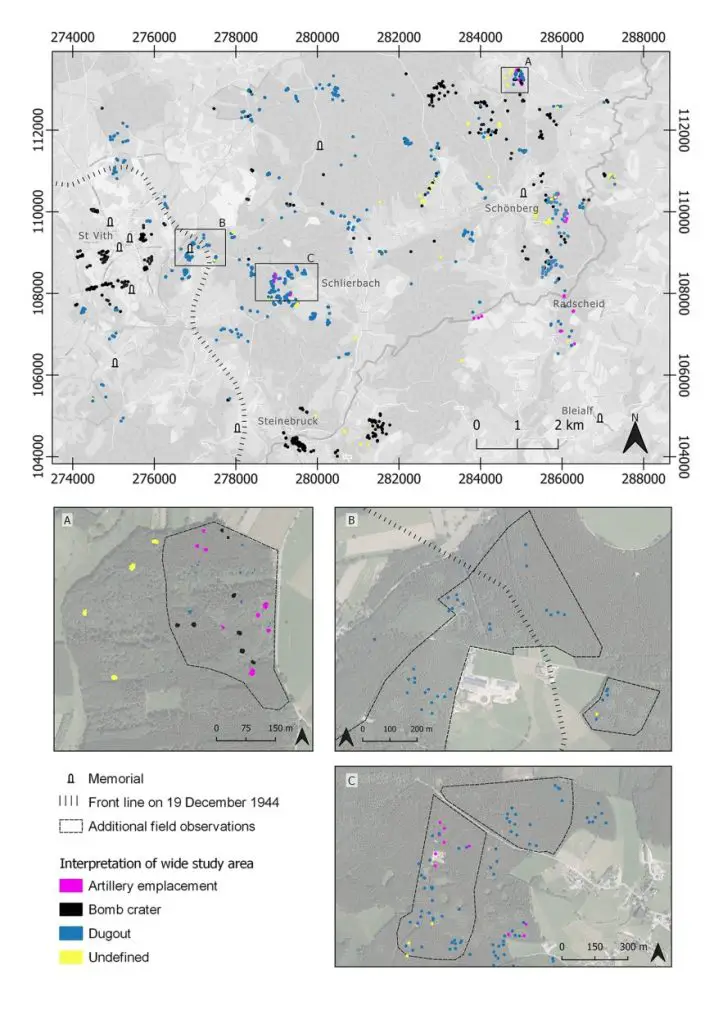
The researchers have identified more than 940 features, which include artillery emplacements, bomb craters, dugouts with an entrance, dugout shelters or storage places, fox holes, trenches, and undefined features.

According to the study authors: “Our study of the landscape and material remains of the Battle of the Bulge through the lens of very-high and low-resolution LiDAR data has identified a rich archaeological landscape associated with US Army defensive lines and both ground combat and aerial bombing in late 1944 and early 1945 in the central sector of the Ardennes Offensive.”

- Advertisement -

This new layer of information will contribute to heritage considerations around the Second World War landscapes of the Ardennes and complements the existing collection of commemorative monuments.

“Our results indicate that the combination of heavily wooded landscapes and the complexity and large scale of the Ardennes Offensive offer great research potential at St Vith and elsewhere across the region’s former battlefields, in Belgium and neighbouring Luxembourg and Germany. Our work also prompts debate on managing the region’s heritage and the need for a more comprehensive archaeological survey and analysis of this important theatre of operations in north-western Europe,” said the study authors.


Antiquity

https://doi.org/10.15184/aqy.2023.95

Header Image Credit : Public Domain

- Advertisement -

Stay Updated: Follow us on iOS, Android, Google News, Facebook, Instagram, Twitter, Threads, TikTok, LinkedIn, and our newsletter

spot_img
Mark Milligan
Mark Milligan
Mark Milligan is a multi-award-winning journalist and the Managing Editor at HeritageDaily. His background is in archaeology and computer science, having written over 8,000 articles across several online publications. Mark is a member of the Association of British Science Writers (ABSW), the World Federation of Science Journalists, and in 2023 was the recipient of the British Citizen Award for Education, the BCA Medal of Honour, and the UK Prime Minister's Points of Light Award.
spot_img
spot_img

Mobile Application

spot_img

Related Articles

Study identifies urban metropolis at X’baatún

Significant progress is being made in the recognition and documentation of X’baatún, a little-known Maya archaeological site located within Oxwatz Park in the ejido of Tekal de Venegas, Yucatán.

LiDAR reveals lost ancient landscape in Andean Chocó

Deep beneath the dense rainforest of the Andean Chocó, north-west of Quito, an ancient pre-Hispanic landscape is emerging using LiDAR (Light Detection and Ranging).

Pristine medieval gold ring discovered in Tønsberg

For most archaeologists, the chance to unearth a pristine artefact from the medieval period is a once-in-a-lifetime event.

Ancient purification bath found beneath Western Wall Plaza

A rock-cut mikveh from the late Second Temple period has been uncovered during excavations beneath Jerusalem’s Western Wall Plaza.

Rare Roman-Era enamelled fibula found near Grudziądz

A rare, enamelled fibula unearthed near Grudziądz is being hailed as only the second discovery of its kind in Poland.

War crimes of the Red Army unearthed near Duczów Małe

Archaeologists from POMOST – the Historical and Archaeological Research Laboratory – have uncovered physical evidence of war crimes committed by the Red Army during WWII.

Prehistoric tomb rediscovered on the Isle of Bute

An early Bronze Age tomb has been rediscovered on the Isle of Bute, an island in the Firth of Clyde in Scotland.

Flail-type weapon associated with Battle of Grunwald discovered near Gietrzwałd

A flail type weapon known as a kiścień has been discovered by detectorists from the Society of Friends of Olsztynek - Exploration Section "Tannenberg".