Date:

Researchers create demonic map from folklore sources

Researchers from the Polish Academy of Sciences have created a cartometric map to indicate the places drawn from ethnographic and folklore sources linked to demonic and mythological creatures.

The map is part of a study published in the Journal of Maps, that shows the historical regions of Pomerania and Mecklenburg at a scale of 1:720,000.

- Advertisement -

This study seeks to blend the artistic and symbolic features of Renaissance maps with modern GIS tools, pinpointing the origins of stories about werewolves, devils, dragons, house spirits, giants, and elves, as recorded by German and Polish folklorists.

A total of 1,200 supernatural accounts written by 19th and early 20th-century folklorists were mapped across 600 locations, each tied to specific landscape features.

Image Credit : Journal of Maps

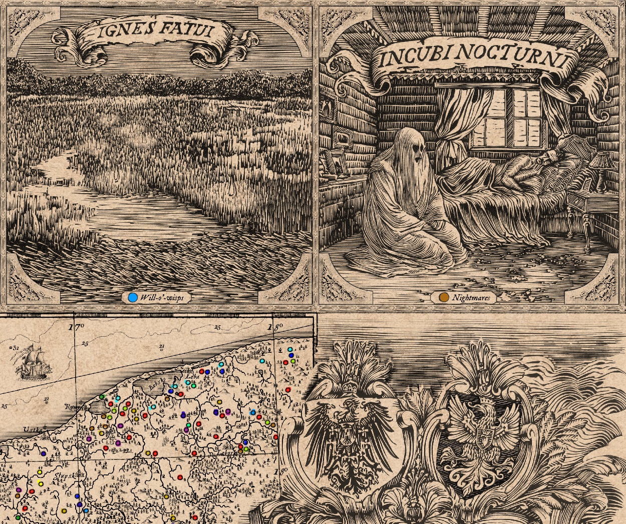
“We were mainly interested in local stories about uncanny events associated with a specific place. For example, religious legends in which it was imagined that witches met on this particular mountain, this boulder was once thrown by a giant, the devil built a dam on the lake or will-o’-the-wisp appeared in this swamp,” said Ethnologist Dr. Robert Piotrowski from the Interdisciplinary Anthropocene Research Team at the Institute of Geography and Spatial Organisation of the Polish Academy of Sciences.

The authors of the study felt that the aesthetics of Italian Renaissance maps would best reflect the climate of the era as they were regarded as works of art, with many considered masterpieces of refined craftsmanship that were famous for their depictions of monsters.

- Advertisement -

“In the past, these monsters were supposed to fill blank spaces – for example, water or places on maps that were not yet fully known,” explained Dr. Dariusz Brykała, a geographer specialising in the history of cartography from IGiPZ PAN.

According to the study authors, these maps can now draw on historical techniques and aesthetics while serving as a lens to explore the evolution of cartography, which has transitioned since World War II from an artful and scientific practice to modern, digital, and interactive forms.

The map is available online for free as part of a scientific publication in the Journal of Maps.

Header Image Credit : Journal of Maps

Sources : PAPhttps://doi.org/10.1080/17445647.2024.2434015

- Advertisement -

Stay Updated: Follow us on iOS, Android, Google News, Facebook, Instagram, Twitter, Threads, TikTok, LinkedIn, and our newsletter

spot_img
Mark Milligan
Mark Milligan
Mark Milligan is a multi-award-winning journalist and the Managing Editor at HeritageDaily. His background is in archaeology and computer science, having written over 8,000 articles across several online publications. Mark is a member of the Association of British Science Writers (ABSW), the World Federation of Science Journalists, and in 2023 was the recipient of the British Citizen Award for Education, the BCA Medal of Honour, and the UK Prime Minister's Points of Light Award.
spot_img
spot_img

Mobile Application

spot_img

Related Articles

Pre-Hispanic funerary remains uncovered in Oaxaca

The National Institute of Anthropology and History (INAH), together with the Ministry of Culture of the Government of Mexico and the INAH Oaxaca Center, has confirmed the discovery of significant archaeological remains in the municipality of San Pedro Jaltepetongo, in the state of Oaxaca.

Bronze reliquary cross unearthed in ancient Lystra

A rare bronze reliquary cross has been discovered during excavations of a church complex in the ancient city of Lystra, located in the Meram district of Konya, central Türkiye.

Discovery of monumental sacred lake at Karnak

Recent archaeological investigations at the Karnak temple complex in Luxor, Egypt, have revealed a previously unknown sacred lake.

Preserved hilltop settlement provides rare insight into Bronze Age life

Archaeologists have uncovered a preserved hilltop settlement following a major excavation at Harden Quarry in the Cheviot Hills straddling the Anglo-Scottish border.

Archaeologists find earliest evidence of wooden tools used by humans              

An international group of researchers has discovered the oldest known handheld wooden tools used by humans.

11th-century English monk first identified the cycles of Halley’s Comet

According to a new study published in arXiv, an 11th-century English monk first documented multiple appearances of Halley’s Comet, more than 600 years before Edmond Halley codified its orbit.

Ancient mega-site “cities” challenges long-held perceptions of urban origins

An archaeological site in Ukraine is attracting ever-increasing international interest as scientists rethink where the world’s earliest cities might have emerged.

Rare wheel cross discovery provides new evidence for early Christianisation

A bronze wheel, dated to the 10th or 11th century AD, has been discovered in the Havelland region of Brandenburg, Germany.