

Fort Drum, nicknamed the “Concrete Battleship”, is a fortified island situated at the mouth of Manila Bay in the Philippines.
Previously known as El Fraile Island, the site was acquired by the United States after the Spanish–American War (1898), a conflict that saw the United States emerge as the dominant power in the Caribbean region and the acquisition of Puerto Rico, Guam, and the Philippines.
The American Board of Fortifications planned for El Fraile Island to be developed into a mine control and casemate station as part of the Harbor Defenses of Manila and Subic Bays. Along with Fort Drum, a defensive chain was devised that included Fort Mills (Corregidor), Fort Hughes (Caballo Island), Fort Frank (Carabao Island), and Fort Wint (Grande Island).
However, the War Department decided to level El Fraile Island and commissioned the U.S. Army Corps of Engineers to build a 20-foot thick steel-reinforced concrete deck armed with 12-inch and 14-inch guns mounted in twin armoured turrets named Marshall (after Brigadier General William Louis Marshall) and Wilson (after Brigadier General John Moulder Wilson). Secondary armament was provided by two pairs of 6-inch guns mounted in armoured casemates on either side of the main structure.
Fort Drum entered active service in 1914, garrisoned by approximately 240 officers and enlisted men. Although not intentional as the concrete construction followed the natural contours of El Fraile Island, from a distance the fort resembles a battleship, thus the nickname of “Concrete Battleship.”
Following the invasion of Luzon during WW2 by the Japanese Imperial Army, Fort Drum became the first American battery of seacoast artillery to open fire on the Japanese, fending off a Japanese-commandeered inter-island steamer.
After several air raids and sustained fire from Japanese 150mm howitzer batteries positioned on the mainland near Ternate, Fort Drum surrendered to Japanese forces following the Fall of Corregidor on the 6th May, 1942, but not before destroying the armoured turrets.
Following the US offensive to reclaim Manila in 1945, Fort Drum stood as the final Japanese stronghold in Manila Bay. After intense aerial and naval bombardment by US forces, a modified Landing Ship Medium (LSM) transported US troops consisting of members of the 2nd Battalion, 151st Infantry Regiment, 38th Infantry Division, and a detachment of the 113th Combat Engineer Battalion, who quickly gained control of the fort’s upper deck.
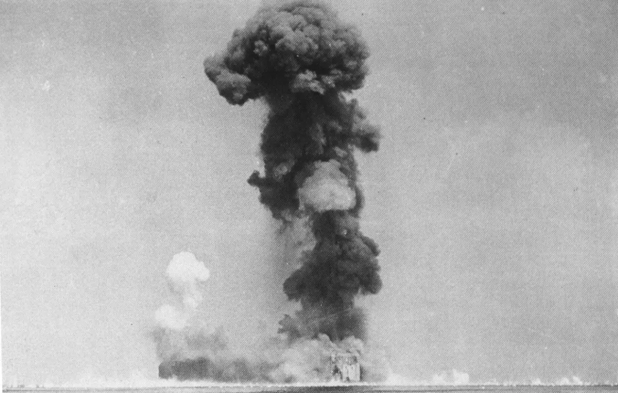
Rather than attempting to break into the battery, the combat engineers pumped a gasoline mixture through air vents on the top deck, and used a timed fuse of TNT to detonate incendiary grenades inside the structure. The explosion forced open a 1-ton hatch to a height of 300 feet, and caused significant damage to sections of the fort’s reinforced concrete walls.
Due to the intense heat and ongoing internal fires, US troops had to wait 5 days before entering the internal structure, finding the charred remains of 62 Japanese soldiers in the boiler room, and 6 soldiers in the upper floors that died from suffocation.
Following the conclusion of WW2, Fort Drum was decommissioned and became abandoned. In 2001, it was repurposed by the Philippine Coast Guard who fitted an automated light on the top deck for safely guiding ships entering the South Channel of Manila Bay.
Header Image – Fort Drum – Image Credit : Paul Soutar


