Date:

USGS releases first-ever comprehensive geologic map of the moon

Have you ever wondered what kind of rocks make up those bright and dark splotches on the moon? Well, the USGS has just released a new authoritative map to help explain the 4.5-billion-year-old history of our nearest neighbor in space.

For the first time, the entire lunar surface has been completely mapped and uniformly classified by scientists from the USGS, in collaboration with NASA and the Lunar Planetary Institute.

- Advertisement -

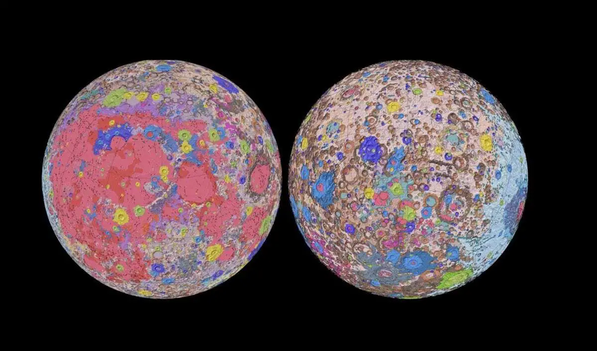
The lunar map, called the “Unified Geologic Map of the Moon,” will serve as the definitive blueprint of the moon’s surface geology for future human missions and will be invaluable for the international scientific community, educators and the public-at-large. The digital map is available online now and shows the moon’s geology in incredible detail (1:5,000,000 scale).

“People have always been fascinated by the moon and when we might return,” said current USGS Director and former NASA astronaut Jim Reilly. “So, it’s wonderful to see USGS create a resource that can help NASA with their planning for future missions.”

To create the new digital map, scientists used information from six Apollo-era regional maps along with updated information from recent satellite missions to the moon. The existing historical maps were redrawn to align them with the modern data sets, thus preserving previous observations and interpretations. Along with merging new and old data, USGS researchers also developed a unified description of the stratigraphy, or rock layers, of the moon. This resolved issues from previous maps where rock names, descriptions and ages were sometimes inconsistent.

“This map is a culmination of a decades-long project,” said Corey Fortezzo, USGS geologist and lead author. “It provides vital information for new scientific studies by connecting the exploration of specific sites on the moon with the rest of the lunar surface.”

- Advertisement -

Elevation data for the moon’s equatorial region came from stereo observations collected by the Terrain Camera on the recent SELENE (Selenological and Engineering Explorer) mission led by JAXA, the Japan Aerospace Exploration Agency. Topography for the north and south poles was supplemented with NASA’s Lunar Orbiter Laser Altimeter data.

US GEOLOGICAL SURVEY

Header Image – New Unified Geologic Map of the Moon with shaded topography from the Lunar Orbiter Laser Altimeter (LOLA). This geologic map is a synthesis of six Apollo-era regional geologic maps, updated based on data from recent satellite missions. It will serve as a reference for lunar science and future human missions to the Moon. – Image Credit : NASA/GSFC/USGS

- Advertisement -

Stay Updated: Follow us on iOS, Android, Google News, Facebook, Instagram, Twitter, Threads, TikTok, LinkedIn, and our newsletter

spot_img
Mark Milligan
Mark Milligan
Mark Milligan is multi-award-winning journalist and the Managing Editor at HeritageDaily. His background is in archaeology and computer science, having written over 8,000 articles across several online publications. Mark is a member of the Association of British Science Writers (ABSW), the World Federation of Science Journalists, and in 2023 was the recipient of the British Citizen Award for Education, the BCA Medal of Honour, and the UK Prime Minister's Points of Light Award.
spot_img
spot_img
spot_img

Mobile Application

spot_img

Related Articles

Caral burial unearthed at Áspero: Elite woman found remarkably preserved

Archaeologists from the Caral Archaeological Zone (ZAC), led by Dr. Ruth Shady Solís from the Ministry of Culture, have discovered a well-preserved burial at the Áspero archaeological site in Barranca Province, Peru.

Mesolithic figurine found in Damjili Cave offers new clues to Neolithic transition

A stone figurine discovered in Damjili Cave, western Azerbaijan, is providing archaeologists with new insights into the cultural and symbolic transition from the Mesolithic to Neolithic in the South Caucasus.

Bite marks confirm gladiators fought lions at York

A recent study published in PLOS One has identified bite marks on human remains excavated from Driffield Terrace, a Roman cemetery on the outskirts of York, England.

Treasures of the Alanian culture found in Alkhan-Kala necropolis

Archaeologists have discovered an intact burial mound containing the tomb of an Alanian elite during excavations at Alkhan-Kala west of Grozny, Chechnya.

Significant archaeological discoveries near Inverness

Archaeologists have made several major discoveries at the site of the upcoming Old Petty Championship Golf Course at Cabot Highlands, near Inverness, Scotland.

Maya ritual offering found in Yucatán caves

Archaeologists from the National Institute of Anthropology and History (INAH) have recovered a globular ceramic pot in Zumpango Cave, part of the extensive Garra de Jaguar system.

Archaeologists find UAE’s first major Iron Age necropolis

The Department of Culture and Tourism in Abu Dhabi has announced the discovery of the first major Iron Age necropolis in the United Arab Emirates.

Ramses III inscription discovered in Jordan’s Wadi Rum

Jordan’s Ministry of Tourism and Antiquities has announced the discovery of an inscription bearing the seal of Ramses III in the Wadi Rum Reserve, Jordan.