Date:

Archaeologists identify Roman road network

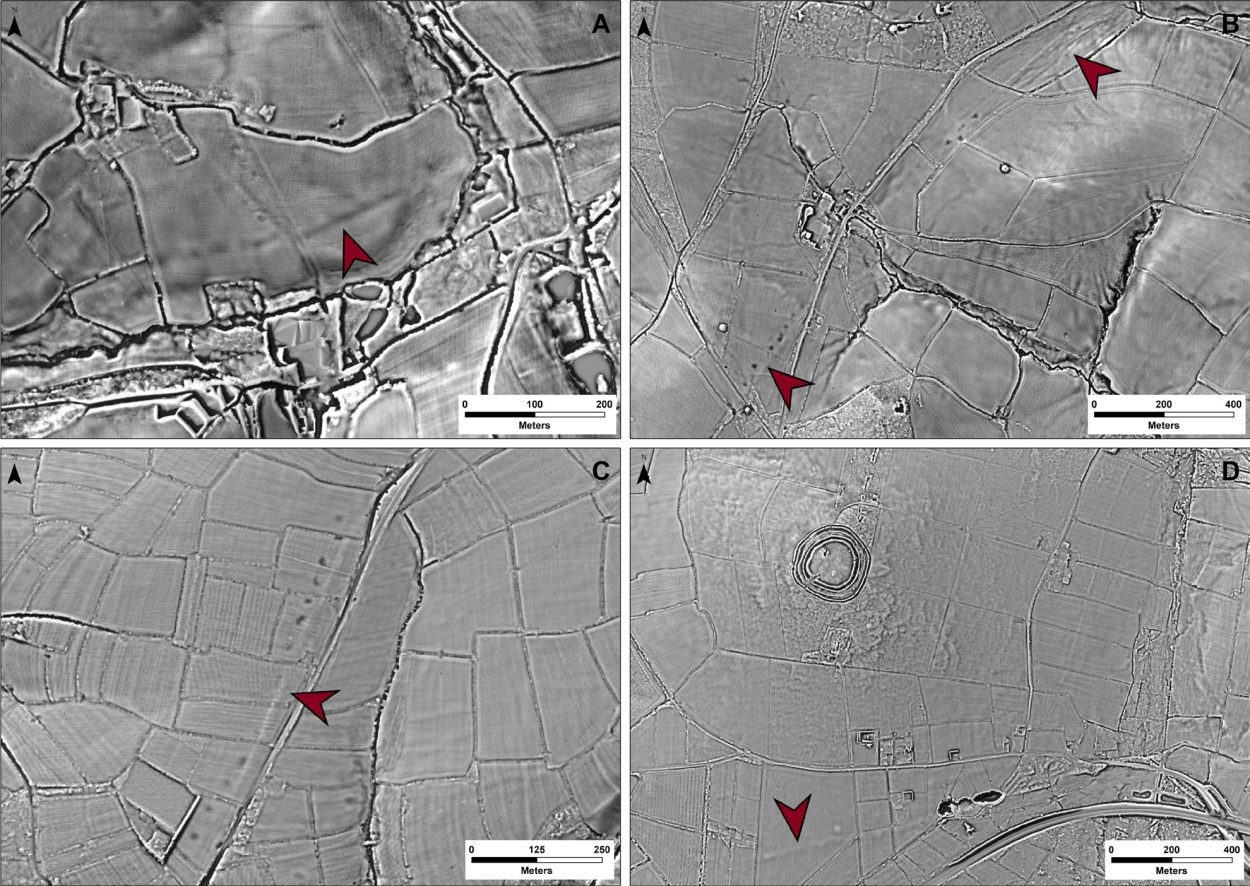
Archaeologists from the University of Exeter have used laser scans to reveal a Roman road network that spanned Devon and Cornwall.

The discovery was made as part of the Environment Agency’s National LiDAR Programme, showing new sections of Roman roads west of the previously known boundary that connected significant settlements with military forts.

- Advertisement -

By using advanced geographical modelling that looks at gradients and flood risk data, the researchers successfully mapped the complete scope of the network and gained valuable insights into its purpose.

Contrary to the assumption that Exeter served as the primary nerve centre, the findings reveal that North Tawton played a crucial role by facilitating strategically important connections with tidal estuaries located both to the north and south of Bodmin and Dartmoor.

Image Credit : The Environment Agency

Dr Christopher Smart from the University of Exeter, said: “Despite more than 70 years of scholarship, published maps of the Roman road network in southern Britain have remained largely unchanged and all are consistent in showing that west of Exeter, Roman Isca, there was little solid evidence for a system of long-distance roads”

“But the recent availability of seamless LiDAR coverage for Britain has provided the means to transform our understanding of the Roman road network that developed within the province, and nowhere more so than in the far south western counties, in the territory of the Dumnonii,” added Dr Smart.

- Advertisement -

According to the study published in the Journal of Computer Applications in Archaeology, the primary objective of the network was to enable the smooth movement of animal-drawn vehicles and to bypass flood-prone areas. The authors suggest that these findings may have significant implications for future archaeological investigations in the region.

“In terms of chronology, it is likely that the proposed network is an amalgam of pre-existing Prehistoric routeways, Roman military campaign roads or “tactical roads” formally adopted into the provincial communications system, and of those constructed during peacetime in a wholly civilian context,” says Dr Fonte from the University of Exeter.

“This evolutionary model is supported by the fact that the network does not solely connect Roman forts and their hinterlands directly, which are often connected by branch roads, but instead appears to serve a broader purpose than required by military supply,” added Dr Fonte.

University of Exeter

Header Image Credit : University of Exeter


- Advertisement -

Stay Updated: Follow us on iOS, Android, Google News, Facebook, Instagram, Twitter, Threads, TikTok, LinkedIn, and our newsletter

spot_img
Mark Milligan
Mark Milligan
Mark Milligan is a multi-award-winning journalist and the Managing Editor at HeritageDaily. His background is in archaeology and computer science, having written over 8,000 articles across several online publications. Mark is a member of the Association of British Science Writers (ABSW), the World Federation of Science Journalists, and in 2023 was the recipient of the British Citizen Award for Education, the BCA Medal of Honour, and the UK Prime Minister's Points of Light Award.
spot_img
spot_img

Mobile Application

spot_img

Related Articles

Archaeologists excavate lost royal palace

Between 2021 and 2023, the long-lost royal palace of Helfta near Lutherstadt Eisleben (Mansfeld-Südharz district) was systematically investigated by the State Office for Heritage Management and Archaeology (LDA) of Saxony-Anhalt.

LiDAR study reveals previously unknown fortress

A previously unknown fortification has been identified in Chełm County, eastern Poland, following a study using airborne laser scanning and other remote sensing techniques.

Study reveals how early humans developed new technologies 400,000 years ago

A sweeping international study of European Stone Age sites is reshaping understanding of how early humans developed new technologies roughly 400,000 years ago.

Guano fuelled the rise of Pre-Inca powerhouse in Peru

A multidisciplinary study reveals that nutrient-rich seabird guano was a key driver of agricultural productivity and sociopolitical expansion in ancient coastal Peru - long before the rise of the Inca Empire.

Medieval panels shed light on Toledo’s storied past

A remarkable medieval discovery hidden beneath a private home in Toledo has shed new light on the city’s storied past.

Bass Rock: Scotland’s Alcatraz

From the beaches of North Berwick, Scotland, Bass Rock is a sheer-sided mass of stone rising abruptly from the steel-grey waters of the Firth of Forth.

Petroglyphs found in Monagas are 8,000 years old

A newly discovered petroglyph in the municipality of Cedeño Municipality is being hailed as one of the oldest known rock art records in Venezuela, with experts estimating the engravings to be between 4,000 and 8,000 years old.

Ancient antler headdress proves contact between hunter-gatherers and the earliest farmers

A new examination of a 7,000-year-old roe deer antler headdress from Eilsleben provides compelling evidence of contact between Central Europe’s last hunter-gatherers and its earliest farming communities.